Weather Alert in Texas
Fire Weather Watch issued April 18 at 2:14PM CDT until April 19 at 10:00PM CDT by NWS Midland/Odessa TX
AREAS AFFECTED: Upton; Terrell
DESCRIPTION: ...A RED FLAG WARNING REMAINS IN EFFECT UNTIL 10 PM CDT /9 PM MDT/ THIS EVENING FOR 20-FT WINDS OF 20 MPH OR MORE, RELATIVE HUMIDITY OF 15% OR LESS, AND HIGH TO VERY HIGH FIRE DANGER FOR SOUTHEAST NEW MEXICO AND MOST OF WEST TEXAS... ...FIRE WEATHER WATCH IN EFFECT FROM SATURDAY AFTERNOON THROUGH SATURDAY EVENING FOR 20-FT WINDS OF 20 MPH OR MORE, RELATIVE HUMIDITY OF 15% OR LESS, AND HIGH TO VERY HIGH FIRE DANGER FOR SOUTHEAST NEW MEXICO AND MOST OF WEST TEXAS... * WINDS...Southeast 15 to 25 mph with gusts up to 35 mph. * RELATIVE HUMIDITY...As low as 15 percent. * RFTI...3 or near-critical. * IMPACTS...Avoid the use of open flames or any activities that may generate sparks. Accidental ignitions will have the potential to grow into dangerous wind-driven wildfires. Fires can start from the smallest of flames or sparks and are highly discouraged. Observe local burn bans. * SEVERITY... FUELS (ERC)...70th-89th percentile...4 (out of 5). WEATHER...Near-Critical...2 (out of 5). FIRE ENVIRONMENT...5 (out of 10).
INSTRUCTION: A Fire Weather Watch means that critical fire weather conditions are forecast to occur. Listen for later forecasts and possible Red Flag Warnings.
Want more detail? Get the Complete 7 Day and Night Detailed Forecast!
Current U.S. National Radar--Current
The Current National Weather Radar is shown below with a UTC Time (subtract 5 hours from UTC to get Eastern Time).

National Weather Forecast--Current
The Current National Weather Forecast and National Weather Map are shown below.

National Weather Forecast for Tomorrow
Tomorrow National Weather Forecast and Tomorrow National Weather Map are show below.

North America Water Vapor (Moisture)
This map shows recent moisture content over North America. Bright and colored areas show high moisture (ie, clouds); brown indicates very little moisture present; black indicates no moisture.

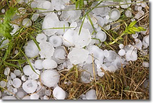
Weather Topic: What is Hail?
Home - Education - Precipitation - Hail
 Next Topic: Hole Punch Clouds
Hail is a form of precipitation which is recognized by large solid balls or
clumps of ice. Hail is created by thunderstorm clouds with strong updrafts of wind.
As the hailstones remain in the updraft, ice is deposited onto them until their
weight becomes heavy enough for them to fall to the earth's surface.
Hail storms can cause significant damage to crops, aircrafts, and man-made structures,
despite the fact that the duration is usually less than ten minutes.
Next Topic: Hole Punch Clouds
Weather Topic: What are Mammatus Clouds?
Home - Education - Cloud Types - Mammatus Clouds
 Next Topic: Nimbostratus Clouds
A mammatus cloud is a cloud with a unique feature which resembles
a web of pouches hanging along the base of the cloud.
In the United States, mammatus clouds tend to form in the warmer months, commonly
in the Midwest and eastern regions.
While they usually form at the bottom of a cumulonimbis cloud, they can also form
under altostratus, altocumulus, stratocumulus, and cirrus clouds. Mammatus clouds
warn that severe weather is close.
Next Topic: Nimbostratus Clouds
Current conditions powered by WeatherAPI.com


