Weather Alert in Idaho
Air Quality Alert issued August 22 at 3:37PM MDT by NWS Missoula MT
AREAS AFFECTED: Clearwater, ID; Idaho, ID
DESCRIPTION: An Air Quality Alert has been issued by the following agencies: Idaho Department of Environmental Quality in Lewiston Nez Perce Tribe ERWM Air Quality Program * WHAT...Air Quality Advisory due to smoke from wildfires. Air Quality Index is forecast to be Unhealthy. * WHERE...Clearwater and Idaho Counties and the Nez Perce Reservation. * WHEN...Until Monday morning, August 25th. * IMPACTS...Those who experience health effects from smoke include children under 18, elders, pregnant women, people with asthma or have difficulty breathing, diabetes, heart problems or otherwise compromised health, and people who have high exposure (those who work, exercise, or spend extensive time outdoors).
INSTRUCTION: Under the most severe pollution level, sensitive groups should avoid outdoor exposure and limit indoor activities, and everyone should restrict their outdoor activities. Idaho Department of Health and Welfare https://healthandwelfare.idaho.gov/health-wellness/environmental- health/idaho-wildfire-and-smoke-information Idaho Smoke Information Hotline: 1-800-345-1007 Lewiston Regional Office: (208) 799-4370.
Want more detail? Get the Complete 7 Day and Night Detailed Forecast!
Current U.S. National Radar--Current
The Current National Weather Radar is shown below with a UTC Time (subtract 5 hours from UTC to get Eastern Time).

National Weather Forecast--Current
The Current National Weather Forecast and National Weather Map are shown below.

National Weather Forecast for Tomorrow
Tomorrow National Weather Forecast and Tomorrow National Weather Map are show below.

North America Water Vapor (Moisture)
This map shows recent moisture content over North America. Bright and colored areas show high moisture (ie, clouds); brown indicates very little moisture present; black indicates no moisture.

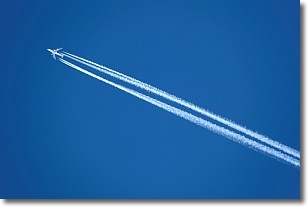
Weather Topic: What are Contrails?
Home - Education - Cloud Types - Contrails
 Next Topic: Cumulonimbus Clouds
A contrail is an artificial cloud, created by the passing of an
aircraft.
Contrails form because water vapor in the exhaust of aircraft engines is suspended
in the air under certain temperatures and humidity conditions. These contrails
are called exhaust contrails.
Another type of contrail can form due to a temporary reduction in air pressure
moving over the plane's surface, causing condensation.
These are called aerodynamic contrails.
When you can see your breath on a cold day, it is also because of condensation.
The reason contrails last longer than the condensation from your breath is
because the water in contrails freezes into ice particles.
Next Topic: Cumulonimbus Clouds
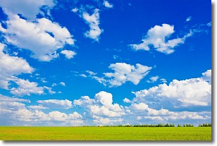
Weather Topic: What are Cumulus Clouds?
Home - Education - Cloud Types - Cumulus Clouds
 Next Topic: Drizzle
Cumulus clouds are fluffy and textured with rounded tops, and
may have flat bottoms. The border of a cumulus cloud
is clearly defined, and can have the appearance of cotton or cauliflower.
Cumulus clouds form at low altitudes (rarely above 2 km) but can grow very tall,
becoming cumulus congestus and possibly the even taller cumulonimbus clouds.
When cumulus clouds become taller, they have a greater chance of producing precipitation.
Next Topic: Drizzle
Current conditions powered by WeatherAPI.com


