Weather Alert in Texas
Blowing Dust Advisory issued April 18 at 10:53AM MDT until April 18 at 8:00PM MDT by NWS El Paso Tx/Santa Teresa NM
AREAS AFFECTED: Northern Hudspeth Highlands/Hueco Mountains; Salt Basin
DESCRIPTION: * WHAT...For the Blowing Dust Advisory, visibility between one-quarter and one mile in blowing dust expected. For the Wind Advisory, southwest winds 25 to 35 mph with gusts up to 50 mph expected. * WHERE...Northern Hudspeth Highlands/Hueco Mountains and Salt Basin. * WHEN...Until 8 PM MDT this evening. * IMPACTS...Hazardous driving conditions due to reduced visibility. Gusty winds will blow around unsecured objects. Tree limbs could be blown down and a few power outages may result.
INSTRUCTION: Persons with respiratory problems should make preparations to stay indoors until the storm passes. Be ready for a sudden drop in visibility to near zero. If you encounter blowing dust or blowing sand on the roadway or see it approaching, pull off the road as far as possible and put your vehicle in park. Turn the lights all the way off and keep foot off the brake pedal. Remember, 'Pull Aside, Stay Alive'. Winds this strong can make driving difficult, especially for high profile vehicles. Use extra caution. Secure outdoor objects.
Want more detail? Get the Complete 7 Day and Night Detailed Forecast!
Current U.S. National Radar--Current
The Current National Weather Radar is shown below with a UTC Time (subtract 5 hours from UTC to get Eastern Time).

National Weather Forecast--Current
The Current National Weather Forecast and National Weather Map are shown below.

National Weather Forecast for Tomorrow
Tomorrow National Weather Forecast and Tomorrow National Weather Map are show below.

North America Water Vapor (Moisture)
This map shows recent moisture content over North America. Bright and colored areas show high moisture (ie, clouds); brown indicates very little moisture present; black indicates no moisture.

Weather Topic: What are Stratus Clouds?
Home - Education - Cloud Types - Stratus Clouds
 Next Topic: Wall Clouds
Stratus clouds are similar to altostratus clouds, but form at a
lower altitude and are identified by their fog-like appearance, lacking the
distinguishing features of most clouds.
Stratus clouds are wider than most clouds, and their base has a smooth, uniform
look which is lighter in color than a nimbostratus cloud.
The presence of a stratus cloud indicates the possibility of minor precipitation,
such as drizzle, but heavier precipitation does not typically arrive in the form
of a stratus cloud.
Next Topic: Wall Clouds
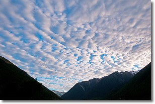
Weather Topic: What are Altocumulus Clouds?
Home - Education - Cloud Types - Altocumulus Clouds
 Next Topic: Altostratus Clouds
Similar to cirrocumulus clouds, altocumulus clouds are
characterized by cloud patches. They are distinguished by larger cloudlets
than cirrocumulus clouds but are still smaller than stratocumulus clouds.
Altocumulus clouds most commonly form in middle altitudes (between 2 and 5 km)
and may resemble, at times, the shape of a flying saucer.
These uncommon formations, called altocumulus lenticularis, are created by uplift
in the atmosphere and are most often seen in close proximity to mountains.
Next Topic: Altostratus Clouds
Current conditions powered by WeatherAPI.com


