Weather Alert in Oregon
Special Weather Statement issued August 21 at 1:57PM PDT by NWS Portland OR
AREAS AFFECTED: East Portland Metro; West Columbia River Gorge of Oregon above 500 ft; West Columbia River Gorge I-84 Corridor; Central Columbia River Gorge I-84 Corridor; East Clark County Lowlands; West Columbia River Gorge - SR 14; Central Columbia River Gorge - SR 14; South Washington Cascades
DESCRIPTION: Breezy easterly winds will develop Friday morning and continue through Friday evening for the eastern Portland/Vancouver metro, and through Friday night for the Columbia River Gorge and adjacent Cascade ridgetops. Winds will be strongest on exposed ridgetops where wind gusts will most likely peak between 25-35 mph. Elsewhere, expect wind gusts between 15-20 mph, except up to 30 mph in the western Columbia River Gorge. The breezy east winds will occur simultaneously with low relative humidity values of 20-30% or less, resulting in near critical fire weather conditions. Use extra caution with potential ignition sources, especially in grassy areas. Outdoor burning is not recommended.
INSTRUCTION: N/A
Want more detail? Get the Complete 7 Day and Night Detailed Forecast!
Current U.S. National Radar--Current
The Current National Weather Radar is shown below with a UTC Time (subtract 5 hours from UTC to get Eastern Time).

National Weather Forecast--Current
The Current National Weather Forecast and National Weather Map are shown below.

National Weather Forecast for Tomorrow
Tomorrow National Weather Forecast and Tomorrow National Weather Map are show below.

North America Water Vapor (Moisture)
This map shows recent moisture content over North America. Bright and colored areas show high moisture (ie, clouds); brown indicates very little moisture present; black indicates no moisture.

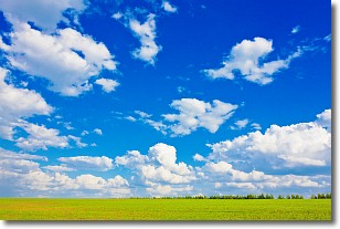
Weather Topic: What are Cumulus Clouds?
Home - Education - Cloud Types - Cumulus Clouds
 Next Topic: Drizzle
Cumulus clouds are fluffy and textured with rounded tops, and
may have flat bottoms. The border of a cumulus cloud
is clearly defined, and can have the appearance of cotton or cauliflower.
Cumulus clouds form at low altitudes (rarely above 2 km) but can grow very tall,
becoming cumulus congestus and possibly the even taller cumulonimbus clouds.
When cumulus clouds become taller, they have a greater chance of producing precipitation.
Next Topic: Drizzle
Weather Topic: What is Evaporation?
Home - Education - Precipitation - Evaporation
 Next Topic: Fog
Evaporation is the process which returns water from the earth
back to the atmosphere, and is another crucial process in the water cycle.
Evaporation is the transformation of liquid into gas, and it happens because
molecules are excited by the application of energy and turn into vapor.
In order for water to evaporate it has to be on the surface of a body of water.
Next Topic: Fog
Current conditions powered by WeatherAPI.com


