Weather Alert in Utah
Winter Weather Advisory issued February 24 at 1:21PM MST until February 25 at 5:00PM MST by NWS Salt Lake City UT
AREAS AFFECTED: Wasatch Mountains I-80 North; Wasatch Mountains South of I-80; Western Uinta Mountains
DESCRIPTION: * WHAT...Wet, heavy snow expected above 8500 feet. * WHERE...The Wasatch Mountains, and Western Uinta Mountains. * WHEN...Until 5 PM MST Wednesday. * IMPACTS...Unusually wet and heavy snow combined with strong winds could impact high elevation routes such as the Upper Cottonwoods and Wolf Creek Pass. * ADDITIONAL DETAILS... -Snow totals of 5 to 15 inches, especially for terrain favored by westerly flow such as the Bear River Range. -Winds gusting as high as 80 mph across exposed mountain ridgelines. -Unusually low snow-to-liquid ratios as low as 5-to-1. -Snow levels will rise as high as 9000 to 9500 feet this evening, then lower to around 8000 feet Wednesday morning.
INSTRUCTION: Dangerous conditions already exist in the backcountry, per the Utah Avalanche Center. Heavy, wet snow is expected, so backcountry users should exercise extra caution and consult utahavalanchecenter.org for avalanche forecasts. Slow down and use caution while traveling. For winter road conditions from the Utah Department of Transportation, visit http://www.udottraffic.utah.gov. For graphical depictions of the snowfall forecast, including Official NWS Forecast, High End Amount, and Low End Amount, visit weather.gov/slc/winter.
Want more detail? Get the Complete 7 Day and Night Detailed Forecast!
Current U.S. National Radar--Current
The Current National Weather Radar is shown below with a UTC Time (subtract 5 hours from UTC to get Eastern Time).

National Weather Forecast--Current
The Current National Weather Forecast and National Weather Map are shown below.

National Weather Forecast for Tomorrow
Tomorrow National Weather Forecast and Tomorrow National Weather Map are show below.

North America Water Vapor (Moisture)
This map shows recent moisture content over North America. Bright and colored areas show high moisture (ie, clouds); brown indicates very little moisture present; black indicates no moisture.

Weather Topic: What is Condensation?
Home - Education - Precipitation - Condensation
 Next Topic: Contrails
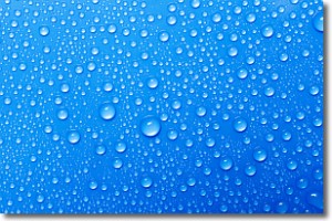
Condensation is the process which creates clouds, and therefore
it is a crucial process in the water cycle.
Condensation is the change of matter from a state of gas into a state of liquid,
and it happens because water molecules release heat into the atmosphere and
become organized into a more closely packed structure, what we might see as
water droplets.
Water is always present in the air around us as a vapor, but it's too small for
us to see. When water undergoes the process of condensation it becomes organized
into visible water droplets. You've probably seen condensation happen before on the
surface of a cold drink!
Next Topic: Contrails
Weather Topic: What are Cumulonimbus Clouds?
Home - Education - Cloud Types - Cumulonimbus Clouds
 Next Topic: Cumulus Clouds
The final form taken by a growing cumulus cloud is the
cumulonimbus cloud, which is very tall and dense.
The tower of a cumulonimbus cloud can soar 23 km into the atmosphere, although
most commonly they stop growing at an altitude of 6 km.
Even small cumulonimbus clouds appear very large in comparison to other cloud types.
They can signal the approach of stormy weather, such as thunderstorms or blizzards.
Next Topic: Cumulus Clouds
Current conditions powered by WeatherAPI.com


