Weather Alert in Wisconsin
Ice Storm Warning issued April 1 at 2:15PM CDT until April 2 at 10:00AM CDT by NWS La Crosse WI
AREAS AFFECTED: Jackson
DESCRIPTION: ...FREEZING RAIN IMPACTS THE AREA TONIGHT INTO THURSDAY MORNING... .Freezing rain develops overnight and persists into Thursday morning, ending from south to north through the morning hours. Greatest ice accumulations are forecast along and north of Interstate 94 with icing amounts of a quarter to nearly half an inch possible in a few locations. Closer to Interstate 90, impacts vary more in space and time with ridge tops and bridges possibly seeing more impacts versus the valleys and ground. * WHAT...Significant icing expected. Ice accumulations between two tenths and half an inch with additional snow and sleet accumulations around 1 inch. Winds gusting as high as 35 mph. * WHERE...Jackson County. * WHEN...From midnight tonight to 10 AM CDT Thursday. * IMPACTS...Power outages and tree damage are likely due to the ice. Travel could be nearly impossible. The hazardous conditions could impact the Thursday morning commute.
INSTRUCTION: Travel is strongly discouraged. If you must travel, keep an extra flashlight, food and water in your vehicle in case of an emergency. Prepare for possible power outages. Visit 511wi.gov for road conditions.
Want more detail? Get the Complete 7 Day and Night Detailed Forecast!
Current U.S. National Radar--Current
The Current National Weather Radar is shown below with a UTC Time (subtract 5 hours from UTC to get Eastern Time).

National Weather Forecast--Current
The Current National Weather Forecast and National Weather Map are shown below.

National Weather Forecast for Tomorrow
Tomorrow National Weather Forecast and Tomorrow National Weather Map are show below.

North America Water Vapor (Moisture)
This map shows recent moisture content over North America. Bright and colored areas show high moisture (ie, clouds); brown indicates very little moisture present; black indicates no moisture.

Weather Topic: What is Freezing Rain?
Home - Education - Precipitation - Freezing Rain
 Next Topic: Graupel
Freezing rain is a condition where precipitation which has fallen in the form of
water droplets reaches temperatures which are below freezing and freezes upon
coming into contact
with surface objects. The result of this precipitation is a glaze of ice which
can be damaging to plants and man-made structures. A severe onset of freezing
rain which results in a very thick glaze of ice is known as an ice storm.
Next Topic: Graupel
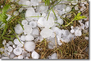
Weather Topic: What is Hail?
Home - Education - Precipitation - Hail
 Next Topic: Hole Punch Clouds
Hail is a form of precipitation which is recognized by large solid balls or
clumps of ice. Hail is created by thunderstorm clouds with strong updrafts of wind.
As the hailstones remain in the updraft, ice is deposited onto them until their
weight becomes heavy enough for them to fall to the earth's surface.
Hail storms can cause significant damage to crops, aircrafts, and man-made structures,
despite the fact that the duration is usually less than ten minutes.
Next Topic: Hole Punch Clouds
Current conditions powered by WeatherAPI.com


