Weather Alert in California
Flood Warning issued February 24 at 7:47PM PST until February 26 at 9:52AM PST by NWS Sacramento CA
AREAS AFFECTED: Tehama, CA
DESCRIPTION: ...The National Weather Service in Sacramento CA has issued a Flood Warning for the following rivers in California... Sacramento River At Tehama Bridge affecting Tehama County. Sacramento River At Vina Woodson Bridge affecting Tehama County. .Minor Flooding At Tehama Bridge and Vina Woodson; Action/Monitor Stage for Most Forecast Points Along the Upper Sacramento River System. For the Upper Sacramento River...including Tehama Bridge and Vina Woodson Bridge...Minor flooding is forecast. * WHAT...Minor flooding is forecast. * WHERE...Sacramento River at Tehama Bridge. * WHEN...From this evening to late Thursday morning. * IMPACTS...At 210.7 feet, Between 210 and 211 feet the county park becomes inaccessible. At 211 feet water begins to enter Driftwood RV fishing resort on east bank of river and just north of the county park. * ADDITIONAL DETAILS... - At 7:00 PM PST Tuesday the stage was 206.1 feet. - Bankfull stage is 206.5 feet. - Forecast...The river is expected to rise above flood stage late this evening to a crest of 212.4 feet tomorrow morning. It will then fall below flood stage tomorrow afternoon. - Flood stage is 209.5 feet. - Flood History...This crest compares to a previous crest of 212.3 feet on 02/19/2024. - http://www.weather.gov/safety/flood
INSTRUCTION: Turn around, don't drown when encountering flooded roads. Most flood deaths occur in vehicles. For more hydrologic information and stage definitions refer to the following web site: wrh.noaa.gov/sto/hydro_data.php The next statement will be issued Wednesday evening at 800 PM PST.
Want more detail? Get the Complete 7 Day and Night Detailed Forecast!
Current U.S. National Radar--Current
The Current National Weather Radar is shown below with a UTC Time (subtract 5 hours from UTC to get Eastern Time).

National Weather Forecast--Current
The Current National Weather Forecast and National Weather Map are shown below.

National Weather Forecast for Tomorrow
Tomorrow National Weather Forecast and Tomorrow National Weather Map are show below.

North America Water Vapor (Moisture)
This map shows recent moisture content over North America. Bright and colored areas show high moisture (ie, clouds); brown indicates very little moisture present; black indicates no moisture.

Weather Topic: What are Contrails?
Home - Education - Cloud Types - Contrails
 Next Topic: Cumulonimbus Clouds
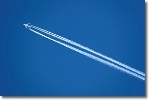
A contrail is an artificial cloud, created by the passing of an
aircraft.
Contrails form because water vapor in the exhaust of aircraft engines is suspended
in the air under certain temperatures and humidity conditions. These contrails
are called exhaust contrails.
Another type of contrail can form due to a temporary reduction in air pressure
moving over the plane's surface, causing condensation.
These are called aerodynamic contrails.
When you can see your breath on a cold day, it is also because of condensation.
The reason contrails last longer than the condensation from your breath is
because the water in contrails freezes into ice particles.
Next Topic: Cumulonimbus Clouds
Weather Topic: What are Cumulus Clouds?
Home - Education - Cloud Types - Cumulus Clouds
 Next Topic: Drizzle
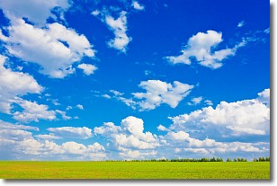
Cumulus clouds are fluffy and textured with rounded tops, and
may have flat bottoms. The border of a cumulus cloud
is clearly defined, and can have the appearance of cotton or cauliflower.
Cumulus clouds form at low altitudes (rarely above 2 km) but can grow very tall,
becoming cumulus congestus and possibly the even taller cumulonimbus clouds.
When cumulus clouds become taller, they have a greater chance of producing precipitation.
Next Topic: Drizzle
Current conditions powered by WeatherAPI.com


