Weather Alert in Colorado
Flood Watch issued August 24 at 2:06PM MDT until August 26 at 12:00AM MDT by NWS Pueblo CO
AREAS AFFECTED: Northern Sangre de Cristo Mountains Between 8500 And 11000 Ft; Northern Sangre de Cristo Mountains above 11000 Ft; Southern Sangre De Cristo Mountains Between 7500 and 11000 Ft; Southern Sangre De Cristo Mountains Above 11000 Ft; Western/Central Fremont County Below 8500 Ft; Wet Mountain Valley Below 8500 Ft; Wet Mountains between 6300 and 10000Ft; Wet Mountains above 10000 Ft; Walsenburg Vicinity/Upper Huerfano River Basin Below 7500 Ft
DESCRIPTION: * WHAT...Flash flooding caused by excessive rainfall is possible. * WHERE...Portions of central and southeast Colorado, including the following areas, in central Colorado, Western/Central Fremont County Below 8500 Feet. In southeast Colorado, Northern Sangre de Cristo Mountains Above 11000 Feet, Northern Sangre de Cristo Mountains Between 8500 And 11000 Feet, Southern Sangre de Cristo Mountains Above 11000 Feet, Southern Sangre de Cristo Mountains Between 7500 and 11000 Feet, Walsenburg Vicinity/Upper Huerfano River Basin Below 7500 Feet, Wet Mountain Valley Below 8500 Feet, Wet Mountains Above 10000 Feet and Wet Mountains between 6300 and 10000 Feet. * WHEN...From Monday afternoon through Monday evening. * IMPACTS...Excessive runoff may result in flooding of rivers, creeks, streams, and other low-lying and flood-prone locations. * ADDITIONAL DETAILS... - Persistent easterly winds, northwest flow aloft, and ample moisture should create thunderstorms over the mountains and mountain valleys with the possibility of training storms. - http://www.weather.gov/safety/flood
INSTRUCTION: You should monitor later forecasts and be prepared to take action should Flash Flood Warnings be issued.
Want more detail? Get the Complete 7 Day and Night Detailed Forecast!
Current U.S. National Radar--Current
The Current National Weather Radar is shown below with a UTC Time (subtract 5 hours from UTC to get Eastern Time).

National Weather Forecast--Current
The Current National Weather Forecast and National Weather Map are shown below.

National Weather Forecast for Tomorrow
Tomorrow National Weather Forecast and Tomorrow National Weather Map are show below.

North America Water Vapor (Moisture)
This map shows recent moisture content over North America. Bright and colored areas show high moisture (ie, clouds); brown indicates very little moisture present; black indicates no moisture.

Weather Topic: What is Rain?
Home - Education - Precipitation - Rain
 Next Topic: Shelf Clouds
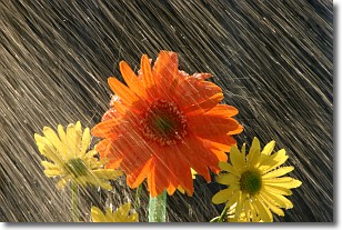
Precipitation in the form of water droplets is called rain.
Rain generally has a tendency to fall with less intensity over a greater period
of time, and when rainfall is more severe it is usually less sustained.
Rain is the most common form of precipitation and happens with greater frequency
depending on the season and regional influences. Cities have been shown to have
an observable effect on rainfall, due to an effect called the urban heat island.
Compared to upwind, monthly rainfall between twenty and forty miles downwind of
cities is 30% greater.
Next Topic: Shelf Clouds
Weather Topic: What is Sleet?
Home - Education - Precipitation - Sleet
 Next Topic: Snow
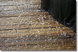
Sleet is a form of precipitation in which small ice pellets are the primary
components. These ice pellets are smaller and more translucent than hailstones,
and harder than graupel. Sleet is caused by specific atmospheric conditions and
therefore typically doesn't last for extended periods of time.
The condition which leads to sleet formation requires a warmer body of air to be
wedged in between two sub-freezing bodies of air. When snow falls through a warmer
layer of air it melts, and as it falls through the next sub-freezing body of air
it freezes again, forming ice pellets known as sleet. In some cases, water
droplets don't have time to freeze before reaching the surface and the result is
freezing rain.
Next Topic: Snow
Current conditions powered by WeatherAPI.com


