Weather Alert in Idaho
Air Quality Alert issued August 25 at 3:16PM PDT by NWS Spokane WA
AREAS AFFECTED: Latah, ID; Lewis, ID; Nez Perce, ID
DESCRIPTION: An Air Advisory Alert has been issued by the following agencies: Idaho Department of Environmental Quality in Lewiston Nez Perce Tribe * WHAT...Air Quality Advisory due to smoke from wildfires. Air Quality Index is forecast to be Unhealthy for Sensitive Groups. * WHERE...Latah, Lewis and Nez Perce Counties, and the Nez Perce Reservation. * WHEN...Until 1100 AM PDT Wednesday morning August 27th for Latah, Nez Perce and Lewis Counties, and until 1100 AM PDT Thursday morning August 28th for the Nez Perce Tribe. * IMPACTS...Members of sensitive groups may experience health effects. Those who experience health effects from smoke include children under 18, elders, pregnant women, people with asthma or have difficulty breathing, diabetes, heart problems or otherwise compromised health, and people who have high exposure (those who work, exercise, or spend extensive time outdoors).
INSTRUCTION: Air pollutants can cause breathing difficulties for children, the elderly, as well as persons with respiratory problems. Those individuals who are sensitive to increased particulate matter or smoke are encouraged to avoid prolonged or strenuous outdoor activity during this advisory. Open burning is prohibited by air quality rules. It is also recommended that all other individuals limit prolonged or strenuous activity outdoors. Idaho Department of Health and Welfare https://healthandwelfare.idaho.gov/health-wellness/environmental- health/idaho-wildfire-and-smoke-information Idaho Smoke Information Hotline: 1-800-345-1007 Idaho DEQ Lewiston Regional Office - (208)-799-4370
Want more detail? Get the Complete 7 Day and Night Detailed Forecast!
Current U.S. National Radar--Current
The Current National Weather Radar is shown below with a UTC Time (subtract 5 hours from UTC to get Eastern Time).

National Weather Forecast--Current
The Current National Weather Forecast and National Weather Map are shown below.

National Weather Forecast for Tomorrow
Tomorrow National Weather Forecast and Tomorrow National Weather Map are show below.

North America Water Vapor (Moisture)
This map shows recent moisture content over North America. Bright and colored areas show high moisture (ie, clouds); brown indicates very little moisture present; black indicates no moisture.

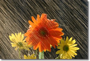
Weather Topic: What is Precipitation?
Home - Education - Precipitation - Precipitation
 Next Topic: Rain
Precipitation can refer to many different forms of water that
may fall from clouds. Precipitation occurs after a cloud has become saturated to
the point where its water particles are more dense than the air below the cloud.
In most cases, precipitation will reach the ground, but it is not uncommon for
precipitation to evaporate before it reaches the earth's surface.
When precipitation evaporates before it contacts the ground it is called Virga.
Graupel, hail, sleet, rain, drizzle, and snow are forms of precipitation, but fog
and mist are not considered precipitation because the water vapor which
constitutes them isn't dense enough to fall to the ground.
Next Topic: Rain
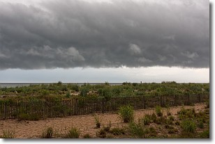
Weather Topic: What are Shelf Clouds?
Home - Education - Cloud Types - Shelf Clouds
 Next Topic: Sleet
A shelf cloud is similar to a wall cloud, but forms at the front
of a storm cloud, instead of at the rear, where wall clouds form.
A shelf cloud is caused by a series of events set into motion by the advancing
storm; first, cool air settles along the ground where precipitation has just fallen.
As the cool air is brought in, the warmer air is displaced, and rises above it,
because it is less dense. When the warmer air reaches the bottom of the storm cloud,
it begins to cool again, and the resulting condensation is a visible shelf cloud.
Next Topic: Sleet
Current conditions powered by WeatherAPI.com


