Weather Alert in Alaska
Wind Advisory issued August 22 at 11:03PM AKDT until August 24 at 1:00AM AKDT by NWS Fairbanks AK
AREAS AFFECTED: South Slopes Of The Eastern Brooks Range; South Slopes Of The Central Brooks Range; Dalton Highway Summits; White Mountains and High Terrain South of the Yukon River; Upper Chena River Valley; Chatanika River Valley
DESCRIPTION: * WHAT...Southwest winds 20 to 30 mph with gusts up to 45 mph expected. The strongest winds are expected above 2000 feet elevation. * WHERE...Chatanika River Valley, Dalton Highway Summits, South Slopes Of The Central Brooks Range, South Slopes Of The Eastern Brooks Range, Upper Chena River Valley, and White Mountains and High Terrain South of the Yukon River. * WHEN...From 4 AM Saturday to 1 AM AKDT Sunday. * IMPACTS...Gusty winds will blow around unsecured objects and may cause tree damage resulting in a few power outages. * ADDITIONAL DETAILS...These strong winds usher in a prolonged period of rainy weather so hunters and recreationists are encouraged to prepare for rising water levels on rivers and their tributaries.
INSTRUCTION: Winds this strong can make driving difficult, especially for high profile vehicles. Use extra caution.
Want more detail? Get the Complete 7 Day and Night Detailed Forecast!
Current U.S. National Radar--Current
The Current National Weather Radar is shown below with a UTC Time (subtract 5 hours from UTC to get Eastern Time).

National Weather Forecast--Current
The Current National Weather Forecast and National Weather Map are shown below.

National Weather Forecast for Tomorrow
Tomorrow National Weather Forecast and Tomorrow National Weather Map are show below.

North America Water Vapor (Moisture)
This map shows recent moisture content over North America. Bright and colored areas show high moisture (ie, clouds); brown indicates very little moisture present; black indicates no moisture.

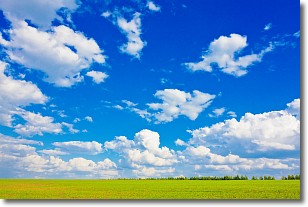
Weather Topic: What are Cumulus Clouds?
Home - Education - Cloud Types - Cumulus Clouds
 Next Topic: Drizzle
Cumulus clouds are fluffy and textured with rounded tops, and
may have flat bottoms. The border of a cumulus cloud
is clearly defined, and can have the appearance of cotton or cauliflower.
Cumulus clouds form at low altitudes (rarely above 2 km) but can grow very tall,
becoming cumulus congestus and possibly the even taller cumulonimbus clouds.
When cumulus clouds become taller, they have a greater chance of producing precipitation.
Next Topic: Drizzle
Weather Topic: What is Evaporation?
Home - Education - Precipitation - Evaporation
 Next Topic: Fog
Evaporation is the process which returns water from the earth
back to the atmosphere, and is another crucial process in the water cycle.
Evaporation is the transformation of liquid into gas, and it happens because
molecules are excited by the application of energy and turn into vapor.
In order for water to evaporate it has to be on the surface of a body of water.
Next Topic: Fog
Current conditions powered by WeatherAPI.com


