Weather Alert in Alaska
Heat Advisory issued August 24 at 6:55PM AKDT until August 25 at 7:00PM AKDT by NWS Juneau AK
AREAS AFFECTED: City of Hyder
DESCRIPTION: * WHAT...Temperatures up to 80. * WHERE...City of Hyder. * WHEN...Until 7 PM AKDT Monday. * IMPACTS...Individuals not accustomed to these unusually hot temperatures for this region may experience heat related illnesses. * ADDITIONAL DETAILS...Warm temperatures are expected Monday afternoon, topping out around 80. Warmest temperatures will be in areas away from sea breeze influence.
INSTRUCTION: Drink plenty of fluids and check up on elderly and vulnerable relatives and neighbors. Young children and pets should never be left unattended in vehicles under any circumstances as vehicle interiors can reach extreme temperatures in as little as 10 minutes Take extra precautions when working in the sun. Wear sunscreen and lightweight, loose fitting clothing. Try to limit strenuous activities to early morning or evening. Take action when you see symptoms of heat exhaustion and heat stroke Close curtains during the daytime to reduce sun insulation into the home and open windows at night to allow the home to cool off. Utilize fans or community buildings with air conditioning.
Want more detail? Get the Complete 7 Day and Night Detailed Forecast!
Current U.S. National Radar--Current
The Current National Weather Radar is shown below with a UTC Time (subtract 5 hours from UTC to get Eastern Time).

National Weather Forecast--Current
The Current National Weather Forecast and National Weather Map are shown below.

National Weather Forecast for Tomorrow
Tomorrow National Weather Forecast and Tomorrow National Weather Map are show below.

North America Water Vapor (Moisture)
This map shows recent moisture content over North America. Bright and colored areas show high moisture (ie, clouds); brown indicates very little moisture present; black indicates no moisture.

Weather Topic: What is Condensation?
Home - Education - Precipitation - Condensation
 Next Topic: Contrails
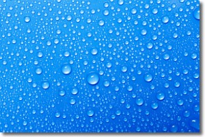
Condensation is the process which creates clouds, and therefore
it is a crucial process in the water cycle.
Condensation is the change of matter from a state of gas into a state of liquid,
and it happens because water molecules release heat into the atmosphere and
become organized into a more closely packed structure, what we might see as
water droplets.
Water is always present in the air around us as a vapor, but it's too small for
us to see. When water undergoes the process of condensation it becomes organized
into visible water droplets. You've probably seen condensation happen before on the
surface of a cold drink!
Next Topic: Contrails
Weather Topic: What are Cumulonimbus Clouds?
Home - Education - Cloud Types - Cumulonimbus Clouds
 Next Topic: Cumulus Clouds
The final form taken by a growing cumulus cloud is the
cumulonimbus cloud, which is very tall and dense.
The tower of a cumulonimbus cloud can soar 23 km into the atmosphere, although
most commonly they stop growing at an altitude of 6 km.
Even small cumulonimbus clouds appear very large in comparison to other cloud types.
They can signal the approach of stormy weather, such as thunderstorms or blizzards.
Next Topic: Cumulus Clouds
Current conditions powered by WeatherAPI.com


