Weather Alert in Colorado
Winter Weather Advisory issued April 18 at 6:04PM MDT until April 19 at 5:00PM MDT by NWS Pueblo CO
AREAS AFFECTED: Western Mosquito Range/East Lake County Above 11000 Ft; Eastern Sawatch Mountains above 11000 Ft; Western Chaffee County Between 9000 and 11000 Ft; Western Mosquito Range/East Chaffee County above 9000Ft; Saguache County West of Continental Divide Below 10000 Ft; La Garita Mountains Above 10000 Ft
DESCRIPTION: * WHAT...Snow. Additional snow accumulations between 8 and 14 inches. Winds gusting as high as 35 mph. * WHERE...Eastern Sawatch Mountains Above 11000 Feet, La Garita Mountains Above 10000 Feet, Saguache County West of Continental Divide Below 10000 Feet, Western Chaffee County Between 9000 and 11000 Feet, Western Mosquito Range/East Chaffee County Above 9000 Feet, and Western Mosquito Range/East Lake County Above 11000 Feet. * WHEN...Until 5 PM MDT Saturday. * IMPACTS...Travel could be difficult.
INSTRUCTION: Slow down and use caution while traveling. The latest road conditions for the state you are calling from can be obtained by calling 5 1 1.
Want more detail? Get the Complete 7 Day and Night Detailed Forecast!
Current U.S. National Radar--Current
The Current National Weather Radar is shown below with a UTC Time (subtract 5 hours from UTC to get Eastern Time).

National Weather Forecast--Current
The Current National Weather Forecast and National Weather Map are shown below.

National Weather Forecast for Tomorrow
Tomorrow National Weather Forecast and Tomorrow National Weather Map are show below.

North America Water Vapor (Moisture)
This map shows recent moisture content over North America. Bright and colored areas show high moisture (ie, clouds); brown indicates very little moisture present; black indicates no moisture.

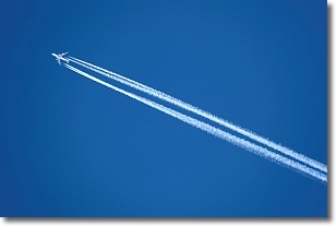
Weather Topic: What are Contrails?
Home - Education - Cloud Types - Contrails
 Next Topic: Cumulonimbus Clouds
A contrail is an artificial cloud, created by the passing of an
aircraft.
Contrails form because water vapor in the exhaust of aircraft engines is suspended
in the air under certain temperatures and humidity conditions. These contrails
are called exhaust contrails.
Another type of contrail can form due to a temporary reduction in air pressure
moving over the plane's surface, causing condensation.
These are called aerodynamic contrails.
When you can see your breath on a cold day, it is also because of condensation.
The reason contrails last longer than the condensation from your breath is
because the water in contrails freezes into ice particles.
Next Topic: Cumulonimbus Clouds
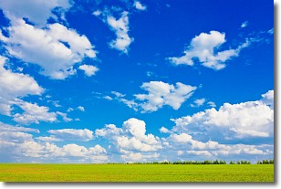
Weather Topic: What are Cumulus Clouds?
Home - Education - Cloud Types - Cumulus Clouds
 Next Topic: Drizzle
Cumulus clouds are fluffy and textured with rounded tops, and
may have flat bottoms. The border of a cumulus cloud
is clearly defined, and can have the appearance of cotton or cauliflower.
Cumulus clouds form at low altitudes (rarely above 2 km) but can grow very tall,
becoming cumulus congestus and possibly the even taller cumulonimbus clouds.
When cumulus clouds become taller, they have a greater chance of producing precipitation.
Next Topic: Drizzle
Current conditions powered by WeatherAPI.com


