Weather Alert in California
Dust Advisory issued August 25 at 3:10PM PDT until August 25 at 4:15PM PDT by NWS Phoenix AZ
AREAS AFFECTED: Imperial, CA
DESCRIPTION: The National Weather Service in Phoenix has issued a * Dust Advisory for... Southwestern Imperial County in southeastern California... * Until 415 PM PDT. * At 309 PM PDT, a wall of dust was along a line extending from near Calexico to near El Centro Naval Airfield to Plaster City. HAZARD...Less than one mile visibility with strong wind in excess of 50 mph. SOURCE...Doppler radar. IMPACT...Hazardous travel. * This includes the following highways... CA Interstate 8 near mile marker 1, and between mile markers 3 and 60. CA Route 111 between mile markers 1 and 19. CA Route 86 between mile markers 1 and 17. Locations impacted include... El Centro, Calexico, Imperial, Plaster City, Ocotillo, Holtville, Mt. Signal, El Centro Naval Airfield, Coyote Wells, Seeley, Bonds Corner, Heber, and Dixieland.
INSTRUCTION: Blowing dust brings reduced visibility, leading to dangerous driving conditions. If driving, avoid blowing dust if possible. If caught in dense blowing dust, pull off the road, turn off your lights and keep your foot off the brake. Motorists should not drive into an area of blowing dust. PULL ASIDE STAY ALIVE! Strong to severe thunderstorms are also possible behind this wall of dust. Keep updated with this quickly evolving situation.
Want more detail? Get the Complete 7 Day and Night Detailed Forecast!
Current U.S. National Radar--Current
The Current National Weather Radar is shown below with a UTC Time (subtract 5 hours from UTC to get Eastern Time).

National Weather Forecast--Current
The Current National Weather Forecast and National Weather Map are shown below.

National Weather Forecast for Tomorrow
Tomorrow National Weather Forecast and Tomorrow National Weather Map are show below.

North America Water Vapor (Moisture)
This map shows recent moisture content over North America. Bright and colored areas show high moisture (ie, clouds); brown indicates very little moisture present; black indicates no moisture.

Weather Topic: What are Stratus Clouds?
Home - Education - Cloud Types - Stratus Clouds
 Next Topic: Wall Clouds
Stratus clouds are similar to altostratus clouds, but form at a
lower altitude and are identified by their fog-like appearance, lacking the
distinguishing features of most clouds.
Stratus clouds are wider than most clouds, and their base has a smooth, uniform
look which is lighter in color than a nimbostratus cloud.
The presence of a stratus cloud indicates the possibility of minor precipitation,
such as drizzle, but heavier precipitation does not typically arrive in the form
of a stratus cloud.
Next Topic: Wall Clouds
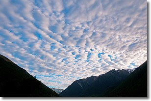
Weather Topic: What are Altocumulus Clouds?
Home - Education - Cloud Types - Altocumulus Clouds
 Next Topic: Altostratus Clouds
Similar to cirrocumulus clouds, altocumulus clouds are
characterized by cloud patches. They are distinguished by larger cloudlets
than cirrocumulus clouds but are still smaller than stratocumulus clouds.
Altocumulus clouds most commonly form in middle altitudes (between 2 and 5 km)
and may resemble, at times, the shape of a flying saucer.
These uncommon formations, called altocumulus lenticularis, are created by uplift
in the atmosphere and are most often seen in close proximity to mountains.
Next Topic: Altostratus Clouds
Current conditions powered by WeatherAPI.com


