Weather Alert in Texas
Flood Warning issued June 13 at 9:27PM CDT until June 15 at 2:50AM CDT by NWS Houston/Galveston TX
AREAS AFFECTED: Brazoria, TX; Fort Bend, TX; Wharton, TX
DESCRIPTION: ...The Flood Warning continues for the following rivers in Texas... San Bernard River near Boling affecting Brazoria, Fort Bend and Wharton Counties. For the San Bernard River...including Sweeny, East Bernard, Boling... Minor flooding is forecast. * WHAT...Moderate flooding is occurring and minor flooding is forecast. * WHERE...San Bernard River near Boling. * WHEN...Until early Sunday morning. * IMPACTS...At 22.0 feet, Moderate lowland flooding begins upstream from the gage with significant backwater flooding up Peach Creek in Wharton County inundating low-lying areas. Minor backwater flooding up Snake Creek in Fort Bend County begins. * ADDITIONAL DETAILS... - At 8:15 PM CDT Friday the stage was 22.6 feet. - Bankfull stage is 14.0 feet. - Recent Activity...The maximum river stage in the 24 hours ending at 8:15 PM CDT Friday was 23.9 feet. - Forecast...The river is expected to fall below flood stage early tomorrow afternoon and continue falling to 4.6 feet Wednesday evening. - Flood stage is 18.0 feet. - Flood History...This crest compares to a previous crest of 22.8 feet on 05/20/2000. - http://www.weather.gov/safety/flood
INSTRUCTION: Please report observed flooding to local emergency services or law enforcement and request they pass this information to the National Weather Service when you can do so safely. Motorists should not attempt to drive around barricades or drive cars through flooded areas. Turn around, don't drown when encountering flooded roads. Most flood deaths occur in vehicles. Additional information is available at www.weather.gov/hgx. The next statement will be issued Saturday afternoon at 330 PM CDT.
Want more detail? Get the Complete 7 Day and Night Detailed Forecast!
Current U.S. National Radar--Current
The Current National Weather Radar is shown below with a UTC Time (subtract 5 hours from UTC to get Eastern Time).

National Weather Forecast--Current
The Current National Weather Forecast and National Weather Map are shown below.

National Weather Forecast for Tomorrow
Tomorrow National Weather Forecast and Tomorrow National Weather Map are show below.

North America Water Vapor (Moisture)
This map shows recent moisture content over North America. Bright and colored areas show high moisture (ie, clouds); brown indicates very little moisture present; black indicates no moisture.

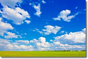
Weather Topic: What are Cumulus Clouds?
Home - Education - Cloud Types - Cumulus Clouds
 Next Topic: Drizzle
Cumulus clouds are fluffy and textured with rounded tops, and
may have flat bottoms. The border of a cumulus cloud
is clearly defined, and can have the appearance of cotton or cauliflower.
Cumulus clouds form at low altitudes (rarely above 2 km) but can grow very tall,
becoming cumulus congestus and possibly the even taller cumulonimbus clouds.
When cumulus clouds become taller, they have a greater chance of producing precipitation.
Next Topic: Drizzle
Weather Topic: What is Evaporation?
Home - Education - Precipitation - Evaporation
 Next Topic: Fog
Evaporation is the process which returns water from the earth
back to the atmosphere, and is another crucial process in the water cycle.
Evaporation is the transformation of liquid into gas, and it happens because
molecules are excited by the application of energy and turn into vapor.
In order for water to evaporate it has to be on the surface of a body of water.
Next Topic: Fog
Current conditions powered by WeatherAPI.com


