Weather Alert in California
Red Flag Warning issued August 20 at 3:34PM PDT until August 23 at 9:00PM PDT by NWS Los Angeles/Oxnard CA
AREAS AFFECTED: Cuyama Valley; San Luis Obispo County Mountains; Santa Ynez Mountains Western Range; Santa Ynez Mountains Eastern Range; Santa Barbara County Interior Mountains
DESCRIPTION: ...RED FLAG WARNING IN EFFECT UNTIL 9 PM PDT SATURDAY FOR AN UNSEASONABLY HOT AND UNSTABLE AIR MASS CAPABLE OF PRODUCING EXTREME FIRE BEHAVIOR FROM VERTICAL PLUME GROWTH... LOW RELATIVE HUMIDITY...AND LOCALLY BREEZY WINDS FOR PORTIONS OF THE MOUNTAINS AND FOOTHILLS OF LOS ANGELES AND VENTURA COUNTIES... ...RED FLAG WARNING IN EFFECT FROM 9 AM PDT THURSDAY TO 9 PM PDT SATURDAY FOR AN UNSEASONABLY HOT AND UNSTABLE AIR MASS CAPABLE OF PRODUCING EXTREME FIRE BEHAVIOR FROM VERTICAL PLUME GROWTH...LOW RELATIVE HUMIDITY...AND LOCALLY BREEZY WINDS FOR PORTIONS OF THE MOUNTAINS AND FOOTHILLS OF SANTA BARBARA AND SAN LUIS OBISPO COUNTIES... .A significant heatwave is on the way for late this week into this weekend, bringing dangerous fire-weather conditions. * TEMPERATURES...Unseasonably hot high temperatures, generally 95- 105 degrees, producing unseasonably unstable conditions. * RELATIVE HUMIDITY...Minimum relative humidity 8-20 percent. * THUNDERSTORMS...There is a less than 10 percent chance of isolated thunderstorms Friday through the weekend, and any accompanying lightning strikes will be capable of starting new fires on the peripheries of rain cores. * WINDS...Diurnal wind patterns with speeds of 5-10 mph gusting to 10-15 mph, locally higher in wind-favored areas such as through passes and canyons. * IMPACTS...If fire ignition occurs, conditions are favorable for extreme fire behavior and rapid fire growth, which could threaten life and property. Be aware of sudden re-direction of fires in response to passing outflow boundaries. * ADDITIONAL DETAILS...Fire-weather headlines may eventually need to be extended into Sunday.
INSTRUCTION: A Red Flag Warning means that fire-weather conditions could potentially become favorable for the development of extreme fire behavior in the coming days. Use extreme caution with anything that can spark a wildfire. Residents near wildland interfaces should be prepared to evacuate if a wildfire breaks out. See readyforwildfire.org and wildfirerisk.org for information.
Want more detail? Get the Complete 7 Day and Night Detailed Forecast!
Current U.S. National Radar--Current
The Current National Weather Radar is shown below with a UTC Time (subtract 5 hours from UTC to get Eastern Time).

National Weather Forecast--Current
The Current National Weather Forecast and National Weather Map are shown below.

National Weather Forecast for Tomorrow
Tomorrow National Weather Forecast and Tomorrow National Weather Map are show below.

North America Water Vapor (Moisture)
This map shows recent moisture content over North America. Bright and colored areas show high moisture (ie, clouds); brown indicates very little moisture present; black indicates no moisture.

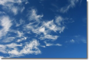
Weather Topic: What are Cirrostratus Clouds?
Home - Education - Cloud Types - Cirrostratus Clouds
 Next Topic: Cirrus Clouds
Cirrostratus clouds are high, thin clouds that form above
20,000 feet and are made mostly of ice crystals. They sometimes look like giant
feathers, horse tails, or curls of hair in the sky.
These clouds are pushed by the jet stream and can move at high speeds reaching
100 mph.
What do they indicate?
They indicate that a precipitation is likely within 24 hours.
Next Topic: Cirrus Clouds
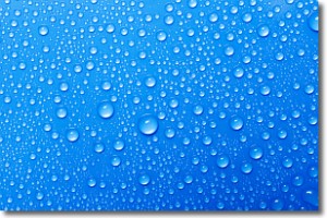
Weather Topic: What is Condensation?
Home - Education - Precipitation - Condensation
 Next Topic: Contrails
Condensation is the process which creates clouds, and therefore
it is a crucial process in the water cycle.
Condensation is the change of matter from a state of gas into a state of liquid,
and it happens because water molecules release heat into the atmosphere and
become organized into a more closely packed structure, what we might see as
water droplets.
Water is always present in the air around us as a vapor, but it's too small for
us to see. When water undergoes the process of condensation it becomes organized
into visible water droplets. You've probably seen condensation happen before on the
surface of a cold drink!
Next Topic: Contrails
Current conditions powered by WeatherAPI.com


