Weather Alert in Utah
Avalanche Advisory issued March 18 at 6:32PM MDT by NWS Salt Lake City UT
AREAS AFFECTED: Wasatch Mountains I-80 North; Wasatch Mountains South of I-80; Western Uinta Mountains; Wasatch Plateau/Book Cliffs; Central Mountains; Southern Mountains
DESCRIPTION: SABSLC * WHAT...The Utah Avalanche Center is issuing a Special Avalanche Advisory for all mountain regions across Utah beginning Thursday, March 19 through Sunday, March 22, as avalanche danger is expected to rise in the coming days. * WHERE...The mountains of Utah and southeastern Idaho. * WHEN...In effect from 6 AM MDT Thursday to 6 AM MDT Monday. * IMPACTS...Record-breaking warm temperatures will rapidly destabilize the snowpack across the state, increasing the likelihood of widespread, spontaneous, destructive wet avalanches. Wet avalances could occur on all aspects and at all elevations, including places that typically stay colder this time of year. Avoid travel on and below steep slopes, including runout zones and terrain traps.
INSTRUCTION: Backcountry travelers should consult www.utahavalanchecenter.org or call 1-888-999-4019 for more detailed information. This Bulletin does not apply to ski areas or highways where avalanche hazard reduction measures are performed.
Want more detail? Get the Complete 7 Day and Night Detailed Forecast!
Current U.S. National Radar--Current
The Current National Weather Radar is shown below with a UTC Time (subtract 5 hours from UTC to get Eastern Time).

National Weather Forecast--Current
The Current National Weather Forecast and National Weather Map are shown below.

National Weather Forecast for Tomorrow
Tomorrow National Weather Forecast and Tomorrow National Weather Map are show below.

North America Water Vapor (Moisture)
This map shows recent moisture content over North America. Bright and colored areas show high moisture (ie, clouds); brown indicates very little moisture present; black indicates no moisture.

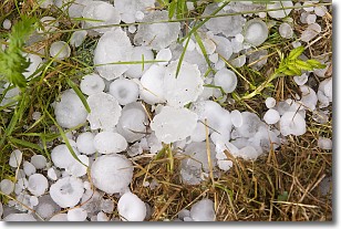
Weather Topic: What is Hail?
Home - Education - Precipitation - Hail
 Next Topic: Hole Punch Clouds
Hail is a form of precipitation which is recognized by large solid balls or
clumps of ice. Hail is created by thunderstorm clouds with strong updrafts of wind.
As the hailstones remain in the updraft, ice is deposited onto them until their
weight becomes heavy enough for them to fall to the earth's surface.
Hail storms can cause significant damage to crops, aircrafts, and man-made structures,
despite the fact that the duration is usually less than ten minutes.
Next Topic: Hole Punch Clouds
Weather Topic: What are Mammatus Clouds?
Home - Education - Cloud Types - Mammatus Clouds
 Next Topic: Nimbostratus Clouds
A mammatus cloud is a cloud with a unique feature which resembles
a web of pouches hanging along the base of the cloud.
In the United States, mammatus clouds tend to form in the warmer months, commonly
in the Midwest and eastern regions.
While they usually form at the bottom of a cumulonimbis cloud, they can also form
under altostratus, altocumulus, stratocumulus, and cirrus clouds. Mammatus clouds
warn that severe weather is close.
Next Topic: Nimbostratus Clouds
Current conditions powered by WeatherAPI.com


