Weather Alert in California
Flood Advisory issued February 24 at 3:10PM PST until February 25 at 6:27PM PST by NWS Reno NV
AREAS AFFECTED: Lassen, CA
DESCRIPTION: ...The National Weather Service in Reno has issued a Flood Advisory for the following rivers in California... Susan River At Susanville affecting Lassen County. For the Susan River near Susanville. Minor flooding is forecast. * WHAT...Minor flooding caused by rain and snowmelt is expected. * WHERE...Susan River at Susanville. * WHEN...From this evening to tomorrow night. * IMPACTS...At 12.0 feet, Flood Stage. Local flooding in Susanville from Lassen Street downstream along Riverside Drive...especially below Paiute Creek which enters river near Alexander Drive. Moderate lowland flooding below Susanville in Johnstonville... Leavitt Lake...Standish... and Litchfield areas. Some rural roads affected by flooding. While the gage is expected to fall quickly below flood stage impacts downstream near Standish will be delayed and more prolonged. * ADDITIONAL DETAILS... - At 2:30 PM PST Tuesday the stage was 7.4 feet. - Forecast...The river will rise to flood stage late this evening near midnight tonight. It will below flood stage at the gage early Wednesday morning. - Action stage is 10.5 feet. - Flood stage is 12.0 feet. - http://www.weather.gov/safety/flood
INSTRUCTION: If you are in the advisory area, remain alert to possible flooding or the possibility of the advisory being upgraded to a warning. Be cautions of nighttime flooding. Please report observed flooding to local emergency services or law enforcement and request they pass this information to the National Weather Service when you can do so safely. Additional information is available at www.weather.gov. The next statement will be issued Wednesday evening at 630 PM PST.
Want more detail? Get the Complete 7 Day and Night Detailed Forecast!
Current U.S. National Radar--Current
The Current National Weather Radar is shown below with a UTC Time (subtract 5 hours from UTC to get Eastern Time).

National Weather Forecast--Current
The Current National Weather Forecast and National Weather Map are shown below.

National Weather Forecast for Tomorrow
Tomorrow National Weather Forecast and Tomorrow National Weather Map are show below.

North America Water Vapor (Moisture)
This map shows recent moisture content over North America. Bright and colored areas show high moisture (ie, clouds); brown indicates very little moisture present; black indicates no moisture.

Weather Topic: What are Stratus Clouds?
Home - Education - Cloud Types - Stratus Clouds
 Next Topic: Wall Clouds
Stratus clouds are similar to altostratus clouds, but form at a
lower altitude and are identified by their fog-like appearance, lacking the
distinguishing features of most clouds.
Stratus clouds are wider than most clouds, and their base has a smooth, uniform
look which is lighter in color than a nimbostratus cloud.
The presence of a stratus cloud indicates the possibility of minor precipitation,
such as drizzle, but heavier precipitation does not typically arrive in the form
of a stratus cloud.
Next Topic: Wall Clouds
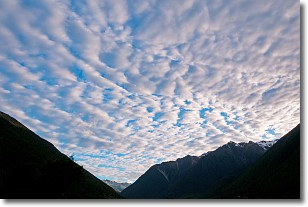
Weather Topic: What are Altocumulus Clouds?
Home - Education - Cloud Types - Altocumulus Clouds
 Next Topic: Altostratus Clouds
Similar to cirrocumulus clouds, altocumulus clouds are
characterized by cloud patches. They are distinguished by larger cloudlets
than cirrocumulus clouds but are still smaller than stratocumulus clouds.
Altocumulus clouds most commonly form in middle altitudes (between 2 and 5 km)
and may resemble, at times, the shape of a flying saucer.
These uncommon formations, called altocumulus lenticularis, are created by uplift
in the atmosphere and are most often seen in close proximity to mountains.
Next Topic: Altostratus Clouds
Current conditions powered by WeatherAPI.com


