Weather Alert in California
Flood Advisory issued February 24 at 3:10PM PST until February 25 at 6:27PM PST by NWS Reno NV
AREAS AFFECTED: Lassen, CA
DESCRIPTION: ...The National Weather Service in Reno has issued a Flood Advisory for the following rivers in California... Susan River At Susanville affecting Lassen County. For the Susan River near Susanville. Minor flooding is forecast. * WHAT...Minor flooding caused by rain and snowmelt is expected. * WHERE...Susan River at Susanville. * WHEN...From this evening to tomorrow night. * IMPACTS...At 12.0 feet, Flood Stage. Local flooding in Susanville from Lassen Street downstream along Riverside Drive...especially below Paiute Creek which enters river near Alexander Drive. Moderate lowland flooding below Susanville in Johnstonville... Leavitt Lake...Standish... and Litchfield areas. Some rural roads affected by flooding. While the gage is expected to fall quickly below flood stage impacts downstream near Standish will be delayed and more prolonged. * ADDITIONAL DETAILS... - At 2:30 PM PST Tuesday the stage was 7.4 feet. - Forecast...The river will rise to flood stage late this evening near midnight tonight. It will below flood stage at the gage early Wednesday morning. - Action stage is 10.5 feet. - Flood stage is 12.0 feet. - http://www.weather.gov/safety/flood
INSTRUCTION: If you are in the advisory area, remain alert to possible flooding or the possibility of the advisory being upgraded to a warning. Be cautions of nighttime flooding. Please report observed flooding to local emergency services or law enforcement and request they pass this information to the National Weather Service when you can do so safely. Additional information is available at www.weather.gov. The next statement will be issued Wednesday evening at 630 PM PST.
Want more detail? Get the Complete 7 Day and Night Detailed Forecast!
Current U.S. National Radar--Current
The Current National Weather Radar is shown below with a UTC Time (subtract 5 hours from UTC to get Eastern Time).

National Weather Forecast--Current
The Current National Weather Forecast and National Weather Map are shown below.

National Weather Forecast for Tomorrow
Tomorrow National Weather Forecast and Tomorrow National Weather Map are show below.

North America Water Vapor (Moisture)
This map shows recent moisture content over North America. Bright and colored areas show high moisture (ie, clouds); brown indicates very little moisture present; black indicates no moisture.

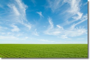
Weather Topic: What are Cirrus Clouds?
Home - Education - Cloud Types - Cirrus Clouds
 Next Topic: Condensation
Cirrus clouds are high-level clouds that occur above 20,000 feet
and are composed mainly of ice crystals.
They are thin and wispy in appearance.
What do they indicate?
They are often the first sign of an approaching storm.
Next Topic: Condensation
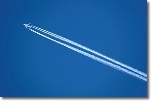
Weather Topic: What are Contrails?
Home - Education - Cloud Types - Contrails
 Next Topic: Cumulonimbus Clouds
A contrail is an artificial cloud, created by the passing of an
aircraft.
Contrails form because water vapor in the exhaust of aircraft engines is suspended
in the air under certain temperatures and humidity conditions. These contrails
are called exhaust contrails.
Another type of contrail can form due to a temporary reduction in air pressure
moving over the plane's surface, causing condensation.
These are called aerodynamic contrails.
When you can see your breath on a cold day, it is also because of condensation.
The reason contrails last longer than the condensation from your breath is
because the water in contrails freezes into ice particles.
Next Topic: Cumulonimbus Clouds
Current conditions powered by WeatherAPI.com


