Weather Alert in Alaska
Winter Weather Advisory issued March 22 at 12:35AM AKDT until March 23 at 4:00AM AKDT by NWS Juneau AK
AREAS AFFECTED: Prince of Wales Island
DESCRIPTION: ...NUMEROUS SNOW SHOWERS CONTINUE THROUGH SATURDAY NIGHT, SECOND ROUND OF SNOW EXPECTED FOR THE SOUTHERN PANHANDLE BY SUNDAY AFTERNOON... .A band of snow is moving northward through the panhandle, with light to moderate snow ongoing at Skagway and Yakutat. This band will continue to move northward out of the area through early Sunday morning. In its wake, the hit or miss snow showers we have seen the previous week will return along the back side of this front with periods of light to moderate snow expected, the winter weather advisories have been extended through Sunday morning for the northern panhandle. Snow will gradually end across the northern panhandle through Sunday afternoon with longer duration advisories continuing for portions of the far southern panhandle. Snowfall accumulations will be variable across the area due to the hit or miss nature of these showers. Rates as high as 1 inch per hour and visibilities down to 1 mile or less will be possible within any heavier showers that repeatedly move over the same location. For the southern panhandle communities, temperatures are expected to start cooling through Sunday with bands of snow moving through the southern and central panhandle by the afternoon into Sunday night, prompting the longer duration Winter Weather Advisory. Accumulations in the south will be the highest on the higher elevations of Prince of Wales Island midday Sunday, but more accumulations expected at sea level by Sunday evening and night as temperatures cool through Sunday evening. * WHAT...Snow. Total snow accumulations of 2 to 5 inches. Visibilities reduced to 1 mile or less. * WHERE...Prince of Wales Island. * WHEN...Until 4 AM AKDT Monday. * IMPACTS...Travel by land, air, and sea could be impacted. * ADDITIONAL DETAILS...Numerous snow showers will continue through Saturday night into Sunday morning. Snowfall accumulations will be variable across the area due to the hit or miss nature of these showers. A secondary system will push through the area on Sunday with higher snow accumulations initially on the higher elevations of the road system before cooling temperatures in the late afternoon and evening brings snow down to the sea level communities for Sunday night.
INSTRUCTION: Slow down and use caution while traveling. People are urged to prepare their property before the onset of winter weather. For the latest road conditions, where available, call 5 1 1 or visit 511.alaska.gov.
Want more detail? Get the Complete 7 Day and Night Detailed Forecast!
Current U.S. National Radar--Current
The Current National Weather Radar is shown below with a UTC Time (subtract 5 hours from UTC to get Eastern Time).

National Weather Forecast--Current
The Current National Weather Forecast and National Weather Map are shown below.

National Weather Forecast for Tomorrow
Tomorrow National Weather Forecast and Tomorrow National Weather Map are show below.

North America Water Vapor (Moisture)
This map shows recent moisture content over North America. Bright and colored areas show high moisture (ie, clouds); brown indicates very little moisture present; black indicates no moisture.

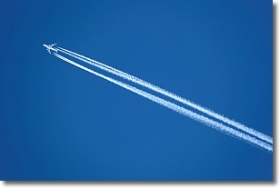
Weather Topic: What are Contrails?
Home - Education - Cloud Types - Contrails
 Next Topic: Cumulonimbus Clouds
A contrail is an artificial cloud, created by the passing of an
aircraft.
Contrails form because water vapor in the exhaust of aircraft engines is suspended
in the air under certain temperatures and humidity conditions. These contrails
are called exhaust contrails.
Another type of contrail can form due to a temporary reduction in air pressure
moving over the plane's surface, causing condensation.
These are called aerodynamic contrails.
When you can see your breath on a cold day, it is also because of condensation.
The reason contrails last longer than the condensation from your breath is
because the water in contrails freezes into ice particles.
Next Topic: Cumulonimbus Clouds
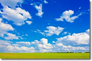
Weather Topic: What are Cumulus Clouds?
Home - Education - Cloud Types - Cumulus Clouds
 Next Topic: Drizzle
Cumulus clouds are fluffy and textured with rounded tops, and
may have flat bottoms. The border of a cumulus cloud
is clearly defined, and can have the appearance of cotton or cauliflower.
Cumulus clouds form at low altitudes (rarely above 2 km) but can grow very tall,
becoming cumulus congestus and possibly the even taller cumulonimbus clouds.
When cumulus clouds become taller, they have a greater chance of producing precipitation.
Next Topic: Drizzle
Current conditions powered by WeatherAPI.com


