Weather Alert in Alaska
Winter Weather Advisory issued March 22 at 12:35AM AKDT until March 23 at 4:00AM AKDT by NWS Juneau AK
AREAS AFFECTED: City and Borough of Wrangell
DESCRIPTION: ...NUMEROUS SNOW SHOWERS CONTINUE THROUGH SATURDAY NIGHT, SECOND ROUND OF SNOW EXPECTED FOR THE SOUTHERN PANHANDLE BY SUNDAY AFTERNOON... .A band of snow is moving northward through the panhandle, with light to moderate snow ongoing at Skagway and Yakutat. This band will continue to move northward out of the area through early Sunday morning. In its wake, the hit or miss snow showers we have seen the previous week will return along the back side of this front with periods of light to moderate snow expected, the winter weather advisories have been extended through Sunday morning for the northern panhandle. Snow will gradually end across the northern panhandle through Sunday afternoon with longer duration advisories continuing for portions of the far southern panhandle. Snowfall accumulations will be variable across the area due to the hit or miss nature of these showers. Rates as high as 1 inch per hour and visibilities down to 1 mile or less will be possible within any heavier showers that repeatedly move over the same location. For the southern panhandle communities, temperatures are expected to start cooling through Sunday with bands of snow moving through the southern and central panhandle by the afternoon into Sunday night, prompting the longer duration Winter Weather Advisory. Accumulations in the south will be the highest on the higher elevations of Prince of Wales Island midday Sunday, but more accumulations expected at sea level by Sunday evening and night as temperatures cool through Sunday evening. * WHAT...Snow. Total snow accumulations of 3 to 5 inches. Visibilities reduced to 1 mile or less. Winds gusting as high as 35 mph. * WHERE...City and Borough of Wrangell. * WHEN...Until 4 AM AKDT Monday. * IMPACTS...Travel by land, air, and sea could be impacted. * ADDITIONAL DETAILS...Numerous snow showers will continue through Saturday night into Sunday morning. Snowfall accumulations will be variable across the area due to the hit or miss nature of these showers. A secondary system will push through the area on Sunday with higher snow accumulations initially on the higher elevations before cooling temperatures in the late afternoon and evening brings snow down to the sea level communities for Sunday night.
INSTRUCTION: Slow down and use caution while traveling. People are urged to prepare their property before the onset of winter weather. For the latest road conditions, where available, call 5 1 1 or visit 511.alaska.gov.
Want more detail? Get the Complete 7 Day and Night Detailed Forecast!
Current U.S. National Radar--Current
The Current National Weather Radar is shown below with a UTC Time (subtract 5 hours from UTC to get Eastern Time).

National Weather Forecast--Current
The Current National Weather Forecast and National Weather Map are shown below.

National Weather Forecast for Tomorrow
Tomorrow National Weather Forecast and Tomorrow National Weather Map are show below.

North America Water Vapor (Moisture)
This map shows recent moisture content over North America. Bright and colored areas show high moisture (ie, clouds); brown indicates very little moisture present; black indicates no moisture.

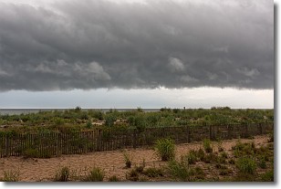
Weather Topic: What are Shelf Clouds?
Home - Education - Cloud Types - Shelf Clouds
 Next Topic: Sleet
A shelf cloud is similar to a wall cloud, but forms at the front
of a storm cloud, instead of at the rear, where wall clouds form.
A shelf cloud is caused by a series of events set into motion by the advancing
storm; first, cool air settles along the ground where precipitation has just fallen.
As the cool air is brought in, the warmer air is displaced, and rises above it,
because it is less dense. When the warmer air reaches the bottom of the storm cloud,
it begins to cool again, and the resulting condensation is a visible shelf cloud.
Next Topic: Sleet
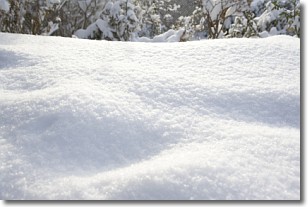
Weather Topic: What is Snow?
Home - Education - Precipitation - Snow
 Next Topic: Stratocumulus Clouds
Snow is precipitation taking the form of ice crystals. Each ice crystal, or snowflake,
has unique characteristics, but all of them grow in a hexagonal structure.
Snowfall can last for sustained periods of time and result in significant buildup
of snow on the ground.
On the earth's surface, snow starts out light and powdery, but as it begins to melt
it tends to become more granular, producing small bits of ice which have the consistency of
sand. After several cycles of melting and freezing, snow can become very dense
and ice-like, commonly known as snow pack.
Next Topic: Stratocumulus Clouds
Current conditions powered by WeatherAPI.com


