Weather Alert in North Carolina
Flood Advisory issued August 12 at 4:01PM EDT until August 12 at 9:45PM EDT by NWS Greenville-Spartanburg SC
AREAS AFFECTED: Union, NC
DESCRIPTION: * WHAT...Nuisance flooding caused by excessive rainfall is developing. * WHERE...A portion of central Union County, North Carolina * WHEN...Until 945 PM EDT Tuesday. * IMPACTS...Nuisance flooding of low-lying areas adjacent to streams and other poor-drainage areas, including farmland, parks, greenways, boat-access areas, golf courses, underpasses, and parking lots. Isolated, shallow flows over roadways is possible. A few flood-prone, low-water crossings may become impassible. A small culvert washout or two is possible. * ADDITIONAL DETAILS... - At 343 PM EDT, The NCEM streamgauge on Bearskin Creek at N Charlotte Ave in Monroe has exceeded the Action Stage of 8.0 feet, indicating nuisance flooding is developing in isolated areas adjacent to the creek, especially in Dickerson Park along the greenway. This is response to earlier moderate rainfall in the headwaters of the Bearskin Creek watershed near Monroe Regional Airport, where isolated 1-1.25" accumulations occurred between 11AM and noon. Bearskin Creek is currently at 8.16' and rising. Expect Bearskin Creek to crest between 8.5 and 9.0 feet within the next 1-2 hours. A crest slightly above 9.0 feet is possible. At 9.0 feet, Bearskin Creek Greenway flooding is expanding from Dickerson Park downstream to Belk Tonowonda Park near IB Shive Dr. Floodwaters are beginning to impact the greenway and the baseball field at Don Griffin Park near Meadow St. - Saturated soils and ongoing runoff from multiple days of rainfall are making area streams extremely sensitive to enhanced runoff. Areas of nuisance flooding adjacent to small streams are possible for rainfall accumulations that are typically too low to cause significant rises. Maintain awareness when adjacent to streams, including along greenways and in parks, whenever rainfall is occurring, and be aware of rapidly rising streams. - Some locations that may experience nuisance flooding include... Monroe. - Http://www.weather.gov/safety/flood
INSTRUCTION: Keep children away from storm drains, culverts, creeks and streams. Water levels can rise rapidly and sweep children away. Stay away or be swept away. River banks and culverts can become unstable and unsafe.
Want more detail? Get the Complete 7 Day and Night Detailed Forecast!
Current U.S. National Radar--Current
The Current National Weather Radar is shown below with a UTC Time (subtract 5 hours from UTC to get Eastern Time).

National Weather Forecast--Current
The Current National Weather Forecast and National Weather Map are shown below.

National Weather Forecast for Tomorrow
Tomorrow National Weather Forecast and Tomorrow National Weather Map are show below.

North America Water Vapor (Moisture)
This map shows recent moisture content over North America. Bright and colored areas show high moisture (ie, clouds); brown indicates very little moisture present; black indicates no moisture.

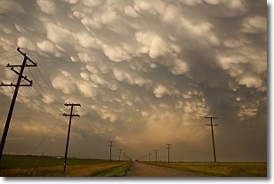
Weather Topic: What are Mammatus Clouds?
Home - Education - Cloud Types - Mammatus Clouds
 Next Topic: Nimbostratus Clouds
A mammatus cloud is a cloud with a unique feature which resembles
a web of pouches hanging along the base of the cloud.
In the United States, mammatus clouds tend to form in the warmer months, commonly
in the Midwest and eastern regions.
While they usually form at the bottom of a cumulonimbis cloud, they can also form
under altostratus, altocumulus, stratocumulus, and cirrus clouds. Mammatus clouds
warn that severe weather is close.
Next Topic: Nimbostratus Clouds
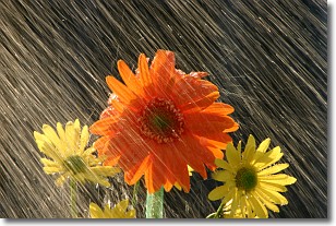
Weather Topic: What is Precipitation?
Home - Education - Precipitation - Precipitation
 Next Topic: Rain
Precipitation can refer to many different forms of water that
may fall from clouds. Precipitation occurs after a cloud has become saturated to
the point where its water particles are more dense than the air below the cloud.
In most cases, precipitation will reach the ground, but it is not uncommon for
precipitation to evaporate before it reaches the earth's surface.
When precipitation evaporates before it contacts the ground it is called Virga.
Graupel, hail, sleet, rain, drizzle, and snow are forms of precipitation, but fog
and mist are not considered precipitation because the water vapor which
constitutes them isn't dense enough to fall to the ground.
Next Topic: Rain
Current conditions powered by WeatherAPI.com


