Weather Alert in Alaska
Coastal Flood Advisory issued August 24 at 11:09PM AKDT until August 25 at 6:00PM AKDT by NWS Anchorage AK
AREAS AFFECTED: Kuskokwim Delta Coast and Nunivak Island
DESCRIPTION: * WHAT...Water levels 1.5 to 2.5 feet above the normal highest tide line. * WHERE...Along the Kuskokwim Delta coast, including the communities of Kipnuk, Kwigillingok, and Kongiganak. * WHEN...11 AM AKDT Monday through 6 PM AKDT Monday. * IMPACTS...Coastal erosion and flooding of low lying areas is likely. * ADDITIONAL DETAILS...Gale force southerly winds will lead to high water levels along the Kuskokwim Delta coast during the Monday afternoon high tide. Half an inch to 1.25 inches of rainfall are also forecast for the area through Monday afternoon, which may fill low-lying areas that normally take on water during lower level coastal flooding events, resulting in higher than normal water levels in addition to the onshore surge. Water levels decrease Monday evening with a receding tide and diminishing southerly winds.
INSTRUCTION: A coastal flood advisory indicates that onshore winds and tides will combine to generate flooding of low areas along the shore.
Want more detail? Get the Complete 7 Day and Night Detailed Forecast!
Current U.S. National Radar--Current
The Current National Weather Radar is shown below with a UTC Time (subtract 5 hours from UTC to get Eastern Time).

National Weather Forecast--Current
The Current National Weather Forecast and National Weather Map are shown below.

National Weather Forecast for Tomorrow
Tomorrow National Weather Forecast and Tomorrow National Weather Map are show below.

North America Water Vapor (Moisture)
This map shows recent moisture content over North America. Bright and colored areas show high moisture (ie, clouds); brown indicates very little moisture present; black indicates no moisture.

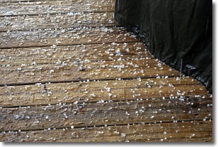
Weather Topic: What is Sleet?
Home - Education - Precipitation - Sleet
 Next Topic: Snow
Sleet is a form of precipitation in which small ice pellets are the primary
components. These ice pellets are smaller and more translucent than hailstones,
and harder than graupel. Sleet is caused by specific atmospheric conditions and
therefore typically doesn't last for extended periods of time.
The condition which leads to sleet formation requires a warmer body of air to be
wedged in between two sub-freezing bodies of air. When snow falls through a warmer
layer of air it melts, and as it falls through the next sub-freezing body of air
it freezes again, forming ice pellets known as sleet. In some cases, water
droplets don't have time to freeze before reaching the surface and the result is
freezing rain.
Next Topic: Snow
Weather Topic: What are Stratocumulus Clouds?
Home - Education - Cloud Types - Stratocumulus Clouds
 Next Topic: Stratus Clouds
Stratocumulus clouds are similar to altocumulus clouds in their
fluffy appearance, but have a slightly darker shade due to their additional mass.
A good way to distinguish the two cloud types is to hold your hand out and measure
the size of an individual cloud; if it is the size of your thumb it is generally
an altocumulus cloud, if it is the size of your hand it is generally a
stratocumulus cloud.
It is uncommon for stratocumulus clouds to produce precipitation, but if they do
it is usually a light rain or snow.
Next Topic: Stratus Clouds
Current conditions powered by WeatherAPI.com


