Weather Alert in Wisconsin
Air Quality Alert issued August 1 at 8:41PM CDT by NWS Green Bay WI
AREAS AFFECTED: Vilas; Oneida; Forest; Florence; Northern Marinette County; Lincoln; Langlade; Menominee; Northern Oconto County; Door; Marathon; Shawano; Wood; Portage; Waupaca; Outagamie; Brown; Kewaunee; Waushara; Winnebago; Calumet; Manitowoc; Southern Marinette County; Southern Oconto County
DESCRIPTION: The Wisconsin Department of Natural Resources has issued an Air Quality Advisory for the following counties: Brown, Calumet, Door, Florence, Forest, Kewaunee, Langlade, Lincoln, Manitowoc, Marathon, Marinette, Menominee, Oconto, Oneida, Outagamie, Portage, Shawano, Vilas, Waupaca, Waushara, Winnebago, and Wood. WHAT...The PM2.5 AQI is expected to reach the Unhealthy for Sensitive Groups to Unhealthy level. WHERE...All of Wisconsin WHEN...Until noon Saturday, August 2 Precautionary/Preparedness Actions: Sensitive groups: Consider rescheduling or moving all activities inside. Go inside if you have symptoms. People with asthma: Follow your asthma action plan and keep quick-relief medicine handy. People with heart disease: Symptoms such as palpitations, shortness of breath, or unusual fatigue may indicate a serious problem. If you have any of these, contact your health care provider. Everyone else: Keep outdoor activities shorter and less intense. Go inside if you have symptoms. Additional Details: Canadian wildfire smoke will continue to impact Wisconsin`s surface air quality over the next several days. A mix of Unhealthy for Sensitive Groups (USG; Orange) AQI and Unhealthy (Red) AQI is still expected tonight, with locations farther north more likely to see heavier smoke. Continued gradual improvement is currently anticipated heading into the weekend, but USG (Orange) AQI to Unhealthy (Red) AQI will remain possible. Conditions will continue to be reevaluated on a day-to-day basis, including updates to the forecast and any associated Air Quality Advisories. For more information on current air quality, please see: https://airquality.wi.gov
INSTRUCTION: N/A
Want more detail? Get the Complete 7 Day and Night Detailed Forecast!
Current U.S. National Radar--Current
The Current National Weather Radar is shown below with a UTC Time (subtract 5 hours from UTC to get Eastern Time).

National Weather Forecast--Current
The Current National Weather Forecast and National Weather Map are shown below.

National Weather Forecast for Tomorrow
Tomorrow National Weather Forecast and Tomorrow National Weather Map are show below.

North America Water Vapor (Moisture)
This map shows recent moisture content over North America. Bright and colored areas show high moisture (ie, clouds); brown indicates very little moisture present; black indicates no moisture.

Weather Topic: What are Stratus Clouds?
Home - Education - Cloud Types - Stratus Clouds
 Next Topic: Wall Clouds
Stratus clouds are similar to altostratus clouds, but form at a
lower altitude and are identified by their fog-like appearance, lacking the
distinguishing features of most clouds.
Stratus clouds are wider than most clouds, and their base has a smooth, uniform
look which is lighter in color than a nimbostratus cloud.
The presence of a stratus cloud indicates the possibility of minor precipitation,
such as drizzle, but heavier precipitation does not typically arrive in the form
of a stratus cloud.
Next Topic: Wall Clouds
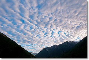
Weather Topic: What are Altocumulus Clouds?
Home - Education - Cloud Types - Altocumulus Clouds
 Next Topic: Altostratus Clouds
Similar to cirrocumulus clouds, altocumulus clouds are
characterized by cloud patches. They are distinguished by larger cloudlets
than cirrocumulus clouds but are still smaller than stratocumulus clouds.
Altocumulus clouds most commonly form in middle altitudes (between 2 and 5 km)
and may resemble, at times, the shape of a flying saucer.
These uncommon formations, called altocumulus lenticularis, are created by uplift
in the atmosphere and are most often seen in close proximity to mountains.
Next Topic: Altostratus Clouds
Current conditions powered by WeatherAPI.com


