Weather Alert in Texas
Severe Thunderstorm Warning issued April 30 at 4:30AM CDT until April 30 at 5:15AM CDT by NWS Norman OK
AREAS AFFECTED: Archer, TX; Baylor, TX; Foard, TX; Hardeman, TX; Knox, TX; Wichita, TX; Wilbarger, TX
DESCRIPTION: SVROUN The National Weather Service in Norman has issued a * Severe Thunderstorm Warning for... Western Archer County in northern Texas... Southwestern Wichita County in northern Texas... Southeastern Foard County in northern Texas... Eastern Knox County in northern Texas... Wilbarger County in northern Texas... Baylor County in northern Texas... Southeastern Hardeman County in northern Texas... * Until 515 AM CDT. * At 430 AM CDT, severe thunderstorms were located along a line extending from near Thalia to 13 miles northeast of Gilliland to near Goree, moving northeast at 45 mph. HAZARD...60 mph wind gusts and penny size hail. SOURCE...Radar indicated. IMPACT...Expect damage to roofs, siding, and trees. * Locations impacted include... Vernon, Seymour, Munday, Electra, Goree, Megargel, Lake Diversion, Westover, Bomarton, Margaret, Lockett, Mabelle, Vera, Medicine Mound, Mankins, Red Springs, Thalia, Dundee, Harrold, and Gilliland.
INSTRUCTION: For your protection move to an interior room on the lowest floor of a building.
Want more detail? Get the Complete 7 Day and Night Detailed Forecast!
Current U.S. National Radar--Current
The Current National Weather Radar is shown below with a UTC Time (subtract 5 hours from UTC to get Eastern Time).

National Weather Forecast--Current
The Current National Weather Forecast and National Weather Map are shown below.

National Weather Forecast for Tomorrow
Tomorrow National Weather Forecast and Tomorrow National Weather Map are show below.

North America Water Vapor (Moisture)
This map shows recent moisture content over North America. Bright and colored areas show high moisture (ie, clouds); brown indicates very little moisture present; black indicates no moisture.

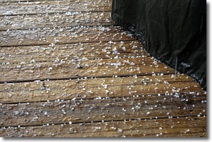
Weather Topic: What is Sleet?
Home - Education - Precipitation - Sleet
 Next Topic: Snow
Sleet is a form of precipitation in which small ice pellets are the primary
components. These ice pellets are smaller and more translucent than hailstones,
and harder than graupel. Sleet is caused by specific atmospheric conditions and
therefore typically doesn't last for extended periods of time.
The condition which leads to sleet formation requires a warmer body of air to be
wedged in between two sub-freezing bodies of air. When snow falls through a warmer
layer of air it melts, and as it falls through the next sub-freezing body of air
it freezes again, forming ice pellets known as sleet. In some cases, water
droplets don't have time to freeze before reaching the surface and the result is
freezing rain.
Next Topic: Snow
Weather Topic: What are Stratocumulus Clouds?
Home - Education - Cloud Types - Stratocumulus Clouds
 Next Topic: Stratus Clouds
Stratocumulus clouds are similar to altocumulus clouds in their
fluffy appearance, but have a slightly darker shade due to their additional mass.
A good way to distinguish the two cloud types is to hold your hand out and measure
the size of an individual cloud; if it is the size of your thumb it is generally
an altocumulus cloud, if it is the size of your hand it is generally a
stratocumulus cloud.
It is uncommon for stratocumulus clouds to produce precipitation, but if they do
it is usually a light rain or snow.
Next Topic: Stratus Clouds
Current conditions powered by WeatherAPI.com


