Weather Alert in Colorado
Red Flag Warning issued February 25 at 5:39AM MST until February 25 at 7:00PM MST by NWS Goodland KS
AREAS AFFECTED: Yuma; Kit Carson County; Cheyenne; Cheyenne; Sherman; Dundy; Hitchcock; Red Willow
DESCRIPTION: Strong westerly winds will spread over the plains of Colorado and adjacent areas Wednesday late Wednesday through the afternoon. Strong winds, combined with very dry fuels will promote the potential for rapid to extreme fire spread. The strongest winds are forecast across Yuma county through the mid afternoon before spreading east through the rest of the afternoon. A strong cold front is expected to sweep across the area around during the mid to late afternoon, shifting winds to the north- northwest making any ongoing fire control efforts difficult. High based showers and isolated storms may pose a dry lightning threat this afternoon as well along with gusty, erratic winds. * AFFECTED AREA...Fire Weather Zones 001 Cheyenne KS, 013 Sherman, 079 Dundy, 080 Hitchcock, 081 Red Willow, 252 Yuma, 253 Kit Carson and 254 Cheyenne CO. * TIMING...From 11 AM MST /noon CST/ this morning to 7 PM MST /8 PM CST/ this evening. * WINDS...Northwest 25 to 35 mph with gusts up to 55 mph. * RELATIVE HUMIDITY...Around 17 percent. * LIGHTNING...Isolated dry storms possible. Little rainfall amounts expected. * IMPACTS...Unpredictable fire behavior. Any fires that develop may rapidly grow and spread out of control.
INSTRUCTION: Comply with burn bans and regulations. Avoid driving on dry grass or brush. Maintain vehicle brakes and tires and secure tow chains to avoid dragging. Never toss lit cigarettes onto the ground.
Want more detail? Get the Complete 7 Day and Night Detailed Forecast!
Current U.S. National Radar--Current
The Current National Weather Radar is shown below with a UTC Time (subtract 5 hours from UTC to get Eastern Time).

National Weather Forecast--Current
The Current National Weather Forecast and National Weather Map are shown below.

National Weather Forecast for Tomorrow
Tomorrow National Weather Forecast and Tomorrow National Weather Map are show below.

North America Water Vapor (Moisture)
This map shows recent moisture content over North America. Bright and colored areas show high moisture (ie, clouds); brown indicates very little moisture present; black indicates no moisture.

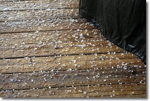
Weather Topic: What is Sleet?
Home - Education - Precipitation - Sleet
 Next Topic: Snow
Sleet is a form of precipitation in which small ice pellets are the primary
components. These ice pellets are smaller and more translucent than hailstones,
and harder than graupel. Sleet is caused by specific atmospheric conditions and
therefore typically doesn't last for extended periods of time.
The condition which leads to sleet formation requires a warmer body of air to be
wedged in between two sub-freezing bodies of air. When snow falls through a warmer
layer of air it melts, and as it falls through the next sub-freezing body of air
it freezes again, forming ice pellets known as sleet. In some cases, water
droplets don't have time to freeze before reaching the surface and the result is
freezing rain.
Next Topic: Snow
Weather Topic: What are Stratocumulus Clouds?
Home - Education - Cloud Types - Stratocumulus Clouds
 Next Topic: Stratus Clouds
Stratocumulus clouds are similar to altocumulus clouds in their
fluffy appearance, but have a slightly darker shade due to their additional mass.
A good way to distinguish the two cloud types is to hold your hand out and measure
the size of an individual cloud; if it is the size of your thumb it is generally
an altocumulus cloud, if it is the size of your hand it is generally a
stratocumulus cloud.
It is uncommon for stratocumulus clouds to produce precipitation, but if they do
it is usually a light rain or snow.
Next Topic: Stratus Clouds
Current conditions powered by WeatherAPI.com


