Weather Alert in Nevada
Hydrologic Outlook issued August 23 at 11:56PM PDT by NWS Elko NV
AREAS AFFECTED: Elko, NV; Eureka, NV
DESCRIPTION: ESFLKN Deep, monsoonal moisture will surge northward into most of Northern and Central Nevada this afternoon through Wednesday evening. As a result, showers and thunderstorms will develop across much of Northern and Central Nevada each afternoon and evening today through Wednesday. Slow storm motions may produce heavy rainfall and localized flooding. Of particular concern are recent, large burn scars, including the Snowstorm Complex near Midas, the Cottonwood Peak fire north of Tuscarora, the Hot Canyon fire northwest of Montello, and the Adobe fire north of Elko. Numerous smaller burn scars from this fire season also remain vulnerable. Residents near recent burned scars should have multiple ways to receive Flash Flood Warnings and be prepared to act quickly. Travelers and recreationists should also remain alert and consider alternate plans.
INSTRUCTION: N/A
Want more detail? Get the Complete 7 Day and Night Detailed Forecast!
Current U.S. National Radar--Current
The Current National Weather Radar is shown below with a UTC Time (subtract 5 hours from UTC to get Eastern Time).

National Weather Forecast--Current
The Current National Weather Forecast and National Weather Map are shown below.

National Weather Forecast for Tomorrow
Tomorrow National Weather Forecast and Tomorrow National Weather Map are show below.

North America Water Vapor (Moisture)
This map shows recent moisture content over North America. Bright and colored areas show high moisture (ie, clouds); brown indicates very little moisture present; black indicates no moisture.

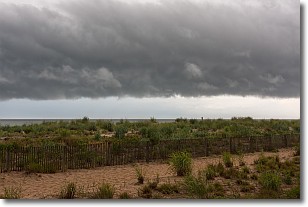
Weather Topic: What are Shelf Clouds?
Home - Education - Cloud Types - Shelf Clouds
 Next Topic: Sleet
A shelf cloud is similar to a wall cloud, but forms at the front
of a storm cloud, instead of at the rear, where wall clouds form.
A shelf cloud is caused by a series of events set into motion by the advancing
storm; first, cool air settles along the ground where precipitation has just fallen.
As the cool air is brought in, the warmer air is displaced, and rises above it,
because it is less dense. When the warmer air reaches the bottom of the storm cloud,
it begins to cool again, and the resulting condensation is a visible shelf cloud.
Next Topic: Sleet
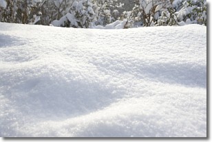
Weather Topic: What is Snow?
Home - Education - Precipitation - Snow
 Next Topic: Stratocumulus Clouds
Snow is precipitation taking the form of ice crystals. Each ice crystal, or snowflake,
has unique characteristics, but all of them grow in a hexagonal structure.
Snowfall can last for sustained periods of time and result in significant buildup
of snow on the ground.
On the earth's surface, snow starts out light and powdery, but as it begins to melt
it tends to become more granular, producing small bits of ice which have the consistency of
sand. After several cycles of melting and freezing, snow can become very dense
and ice-like, commonly known as snow pack.
Next Topic: Stratocumulus Clouds
Current conditions powered by WeatherAPI.com


