Weather Alert in California
Red Flag Warning issued June 1 at 11:26AM PDT until June 2 at 8:00PM PDT by NWS Sacramento CA
AREAS AFFECTED: Eastern Portion of Shasta/Trinity NF; Northern Sacramento Valley to Southern Tehama County Line Below 1000 Ft; Central Sacramento Valley including Glenn/Colusa/Yuba/Northern Sutter/Butte County Below 1000 Ft; Southeast Edge Shasta/Trinity NF and Western Portions of Tehama/Glenn RU; Eastern Mendocino NF
DESCRIPTION: The National Weather Service in Sacramento has issued a Red Flag Warning for gusty winds and low humidity, which is in effect from 2 AM to 8 PM PDT Monday. * Winds...North to northeast winds 15 to 25 mph with gusts 30 to 40 mph expected. Strongest winds are expected across the northern and central Sacramento Valley along and west of Interstate 5 and into the northern Coastal Range. * Humidity...9 to 20 percent. * Highest Threat...Northern Sacramento Valley along and west of the I-5 corridor and the adjacent northern Coastal Range. * Impacts...The combination of gusty winds and low humidity can cause fire to rapidly grow in size and intensity. Outdoor burning is not recommended
INSTRUCTION: A Red Flag Warning means that critical fire weather conditions are either occurring now, or will shortly. A combination of strong winds, low relative humidity, and warm temperatures can contribute to extreme fire behavior.
Want more detail? Get the Complete 7 Day and Night Detailed Forecast!
Current U.S. National Radar--Current
The Current National Weather Radar is shown below with a UTC Time (subtract 5 hours from UTC to get Eastern Time).

National Weather Forecast--Current
The Current National Weather Forecast and National Weather Map are shown below.

National Weather Forecast for Tomorrow
Tomorrow National Weather Forecast and Tomorrow National Weather Map are show below.

North America Water Vapor (Moisture)
This map shows recent moisture content over North America. Bright and colored areas show high moisture (ie, clouds); brown indicates very little moisture present; black indicates no moisture.

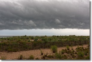
Weather Topic: What are Shelf Clouds?
Home - Education - Cloud Types - Shelf Clouds
 Next Topic: Sleet
A shelf cloud is similar to a wall cloud, but forms at the front
of a storm cloud, instead of at the rear, where wall clouds form.
A shelf cloud is caused by a series of events set into motion by the advancing
storm; first, cool air settles along the ground where precipitation has just fallen.
As the cool air is brought in, the warmer air is displaced, and rises above it,
because it is less dense. When the warmer air reaches the bottom of the storm cloud,
it begins to cool again, and the resulting condensation is a visible shelf cloud.
Next Topic: Sleet
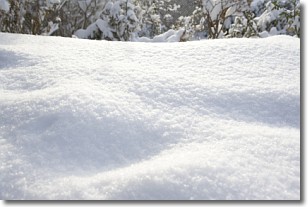
Weather Topic: What is Snow?
Home - Education - Precipitation - Snow
 Next Topic: Stratocumulus Clouds
Snow is precipitation taking the form of ice crystals. Each ice crystal, or snowflake,
has unique characteristics, but all of them grow in a hexagonal structure.
Snowfall can last for sustained periods of time and result in significant buildup
of snow on the ground.
On the earth's surface, snow starts out light and powdery, but as it begins to melt
it tends to become more granular, producing small bits of ice which have the consistency of
sand. After several cycles of melting and freezing, snow can become very dense
and ice-like, commonly known as snow pack.
Next Topic: Stratocumulus Clouds
Current conditions powered by WeatherAPI.com


