Weather Alert in Texas
Flood Watch issued August 14 at 3:42PM CDT until August 15 at 6:00PM CDT by NWS Brownsville TX
AREAS AFFECTED: Southern Hidalgo; Inland Cameron; Coastal Cameron; Cameron Island
DESCRIPTION: Tropical moisture related to Invest 98L could bring locally heavy rainfall possibly enhanced by organized convection could lead to possible isolated to scattered urban poor drainage flooding to Cameron and Southern Hidalgo counties along the Rio Grande Valley on Friday. * WHAT...Flooding caused by excessive rainfall is possible. * WHERE...A portion of Deep South Texas, including the following areas, Cameron Island, Coastal Cameron, Inland Cameron and Southern Hidalgo. * WHEN...From Friday morning through Friday afternoon. * IMPACTS...Excessive runoff may result in flooding of roadways as well as other low-lying and flood-prone locations. Flooding may occur in poor drainage and urban areas. * ADDITIONAL DETAILS... - While there is a higher than usual degree of uncertainty with the evolution of Invest 98L, there is the potential for organized convection to impact somewhere across the Lower Texas Coast. The resultant heavy rainfall could lead to possible isolated to scattered urban poor drainage flooding across Cameron and Southern Hidalgo counties on Friday. - http://www.weather.gov/safety/flood
INSTRUCTION: You should monitor later forecasts and be alert for possible Flood Warnings. Those living in areas prone to flooding should be prepared to take action should flooding develop.
Want more detail? Get the Complete 7 Day and Night Detailed Forecast!
Current U.S. National Radar--Current
The Current National Weather Radar is shown below with a UTC Time (subtract 5 hours from UTC to get Eastern Time).

National Weather Forecast--Current
The Current National Weather Forecast and National Weather Map are shown below.

National Weather Forecast for Tomorrow
Tomorrow National Weather Forecast and Tomorrow National Weather Map are show below.

North America Water Vapor (Moisture)
This map shows recent moisture content over North America. Bright and colored areas show high moisture (ie, clouds); brown indicates very little moisture present; black indicates no moisture.

Weather Topic: What is Freezing Rain?
Home - Education - Precipitation - Freezing Rain
 Next Topic: Graupel
Freezing rain is a condition where precipitation which has fallen in the form of
water droplets reaches temperatures which are below freezing and freezes upon
coming into contact
with surface objects. The result of this precipitation is a glaze of ice which
can be damaging to plants and man-made structures. A severe onset of freezing
rain which results in a very thick glaze of ice is known as an ice storm.
Next Topic: Graupel
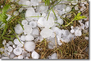
Weather Topic: What is Hail?
Home - Education - Precipitation - Hail
 Next Topic: Hole Punch Clouds
Hail is a form of precipitation which is recognized by large solid balls or
clumps of ice. Hail is created by thunderstorm clouds with strong updrafts of wind.
As the hailstones remain in the updraft, ice is deposited onto them until their
weight becomes heavy enough for them to fall to the earth's surface.
Hail storms can cause significant damage to crops, aircrafts, and man-made structures,
despite the fact that the duration is usually less than ten minutes.
Next Topic: Hole Punch Clouds
Current conditions powered by WeatherAPI.com


