Weather Alert in Alaska
Special Weather Statement issued August 11 at 9:40PM AKDT by NWS Juneau AK
AREAS AFFECTED: City and Borough of Juneau
DESCRIPTION: ..SUICIDE BASIN IS OVERTOPPING... AS OF 10:00 PM MONDAY, THE USGS WEB CAMERA AND LASER GAGE IN SUICIDE BASIN CONTINUE TO SHOW INDICATIONS OF OVER-TOPPING THE ICE DAM WITH ICEBERGS BEING PULLED TOWARDS THE OVERFLOW CHANNEL AND SLOW LOWERING OF WATER LEVELS. THIS MEANS THE BASIN IS AT FULL CAPACITY AND IN THE PAST IT HAS TAKEN UP TO 6 DAYS FROM THE START OF OVER-TOPPING, SUNDAY AUGUST 10TH, FOR THE OUTBURST FLOODING EVENT TO BEGIN. THE WATER LEVEL IN THE BASIN WILL SLOWLY FALL AS THE OVERFLOW CHANNEL ERODES. A FASTER DROP IN WATER LEVELS IN THE BASIN ALONG WITH A RISE ON MENDENHALL LAKE WILL INDICATE A SUB-GLACIER RELEASE AND OUR OFFICE WILL ISSUE A FLOOD WARNING. FROM THAT POINT, THE OUTBURST FLOODING EVENT WOULD TAKE ABOUT 48 HOURS TO PEAK. NOW IS THE TIME TO FINISH UP THE FLOOD PREPARATION/PLANNING AND GET THOSE PLANS "SET" SO THEY CAN BE PUT INTO ACTION, AND "GO" WHEN A FLOOD WARNING IS ISSUED. CHECK BACK REGULARLY FOR UPDATES ON THIS EVOLVING SITUATION. THIS PRODUCT WILL BE UPDATED BY 10 AM MONDAY OR SOONER AS NEEDED. VISIT WEATHER.GOV/JUNEAU/SUICIDEBASIN FOR MORE INFORMATION.
INSTRUCTION: N/A
Want more detail? Get the Complete 7 Day and Night Detailed Forecast!
Current U.S. National Radar--Current
The Current National Weather Radar is shown below with a UTC Time (subtract 5 hours from UTC to get Eastern Time).

National Weather Forecast--Current
The Current National Weather Forecast and National Weather Map are shown below.

National Weather Forecast for Tomorrow
Tomorrow National Weather Forecast and Tomorrow National Weather Map are show below.

North America Water Vapor (Moisture)
This map shows recent moisture content over North America. Bright and colored areas show high moisture (ie, clouds); brown indicates very little moisture present; black indicates no moisture.

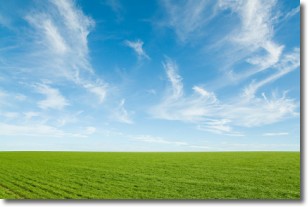
Weather Topic: What are Cirrus Clouds?
Home - Education - Cloud Types - Cirrus Clouds
 Next Topic: Condensation
Cirrus clouds are high-level clouds that occur above 20,000 feet
and are composed mainly of ice crystals.
They are thin and wispy in appearance.
What do they indicate?
They are often the first sign of an approaching storm.
Next Topic: Condensation
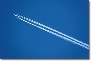
Weather Topic: What are Contrails?
Home - Education - Cloud Types - Contrails
 Next Topic: Cumulonimbus Clouds
A contrail is an artificial cloud, created by the passing of an
aircraft.
Contrails form because water vapor in the exhaust of aircraft engines is suspended
in the air under certain temperatures and humidity conditions. These contrails
are called exhaust contrails.
Another type of contrail can form due to a temporary reduction in air pressure
moving over the plane's surface, causing condensation.
These are called aerodynamic contrails.
When you can see your breath on a cold day, it is also because of condensation.
The reason contrails last longer than the condensation from your breath is
because the water in contrails freezes into ice particles.
Next Topic: Cumulonimbus Clouds
Current conditions powered by WeatherAPI.com


