Weather Alert in California
Flood Warning issued February 25 at 1:50PM PST until February 26 at 2:17PM PST by NWS Sacramento CA
AREAS AFFECTED: Tehama, CA
DESCRIPTION: ...The Flood Warning is extended for the following rivers in California... Sacramento River At Vina Woodson Bridge affecting Tehama County. Sacramento River At Tehama Bridge affecting Tehama County. Sacramento River At Ord Ferry affecting Glenn and Butte Counties. .Recent precipitation has lead to to minor flooding at Ord Ferry, Tehama Bridge and Vina Woodson Bridge on the Upper Sacramento River System. For the Upper Sacramento River...including Tehama Bridge, Vina Woodson Bridge, Ord Ferry...Minor flooding is forecast. * WHAT...Minor flooding is occurring and minor flooding is forecast. * WHERE...Sacramento River at Tehama Bridge. * WHEN...Until early tomorrow afternoon. * IMPACTS...At 206.7 feet, Water into rv park on east side of river. Tires of trailers get wet. At 209.7 feet, Flood stage - Road inside trailer park and turn around site under RR tracks (Tehama/Vina road) become impassible. Water is into area around structures on east side of river. No structural damage. Sheriff's office issues advisory. Makes sure Pelhams Bay, Snug Harbor, River Inn (small trailer parks all in a row on east side of river north of bridge) know of advisory. At 210.7 feet, Between 210 and 211 feet the county park becomes inaccessible. At 211 feet water begins to enter Driftwood RV fishing resort on east bank of river and just north of the county park. * ADDITIONAL DETAILS... - At 1:00 PM PST Wednesday the stage was 213.8 feet. - Bankfull stage is 206.5 feet. - Recent Activity...The maximum river stage in the 24 hours ending at 1:00 PM PST Wednesday was 214.0 feet. - Forecast...The river is expected to fall below flood stage late this evening and continue falling to 201.6 feet early Friday afternoon. - Flood stage is 209.5 feet. - Flood History...This crest compares to a previous crest of 213.5 feet on 12/02/2012. - http://www.weather.gov/safety/flood
INSTRUCTION: Turn around, don't drown when encountering flooded roads. Most flood deaths occur in vehicles. For more hydrologic information and stage definitions refer to the following web site: wrh.noaa.gov/sto/hydro_data.php The next statement will be issued Thursday afternoon at 200 PM PST.
Want more detail? Get the Complete 7 Day and Night Detailed Forecast!
Current U.S. National Radar--Current
The Current National Weather Radar is shown below with a UTC Time (subtract 5 hours from UTC to get Eastern Time).

National Weather Forecast--Current
The Current National Weather Forecast and National Weather Map are shown below.

National Weather Forecast for Tomorrow
Tomorrow National Weather Forecast and Tomorrow National Weather Map are show below.

North America Water Vapor (Moisture)
This map shows recent moisture content over North America. Bright and colored areas show high moisture (ie, clouds); brown indicates very little moisture present; black indicates no moisture.

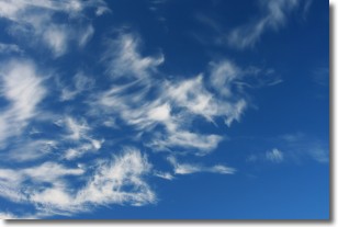
Weather Topic: What are Cirrostratus Clouds?
Home - Education - Cloud Types - Cirrostratus Clouds
 Next Topic: Cirrus Clouds
Cirrostratus clouds are high, thin clouds that form above
20,000 feet and are made mostly of ice crystals. They sometimes look like giant
feathers, horse tails, or curls of hair in the sky.
These clouds are pushed by the jet stream and can move at high speeds reaching
100 mph.
What do they indicate?
They indicate that a precipitation is likely within 24 hours.
Next Topic: Cirrus Clouds
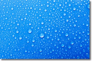
Weather Topic: What is Condensation?
Home - Education - Precipitation - Condensation
 Next Topic: Contrails
Condensation is the process which creates clouds, and therefore
it is a crucial process in the water cycle.
Condensation is the change of matter from a state of gas into a state of liquid,
and it happens because water molecules release heat into the atmosphere and
become organized into a more closely packed structure, what we might see as
water droplets.
Water is always present in the air around us as a vapor, but it's too small for
us to see. When water undergoes the process of condensation it becomes organized
into visible water droplets. You've probably seen condensation happen before on the
surface of a cold drink!
Next Topic: Contrails
Current conditions powered by WeatherAPI.com


