Weather Alert in Wisconsin
Air Quality Alert issued August 1 at 12:13PM CDT by NWS Milwaukee/Sullivan WI
AREAS AFFECTED: Marquette; Green Lake; Fond Du Lac; Sheboygan; Sauk; Columbia; Dodge; Washington; Ozaukee; Iowa; Dane; Jefferson; Waukesha; Milwaukee; Lafayette; Green; Rock; Walworth; Racine; Kenosha
DESCRIPTION: The Wisconsin Department of Natural Resources has issued an Air Quality Advisory for the following counties: Columbia, Dane, Dodge, Fond du Lac, Green, Green Lake, Iowa, Jefferson, Kenosha, Lafayette, Marquette, Milwaukee, Ozaukee, Racine, Rock, Sauk, Sheboygan, Walworth, Washington, Waukesha. WHAT...The PM2.5 AQI is expected to reach the Unhealthy for Sensitive Groups to Unhealthy level. WHERE...All of Wisconsin WHEN...Until noon Saturday, August 2 Precautionary/Preparedness Actions: Sensitive groups: Consider rescheduling or moving all activities inside. Go inside if you have symptoms. People with asthma: Follow your asthma action plan and keep quick-relief medicine handy. People with heart disease: Symptoms such as palpitations, shortness of breath, or unusual fatigue may indicate a serious problem. If you have any of these, contact your health care provider. Everyone else: Keep outdoor activities shorter and less intense. Go inside if you have symptoms. Additional Details: Canadian wildfire smoke will continue to impact Wisconsin`s surface air quality over the next several days. Conditions have improved since Thursday as a pocket of cleaner air has infiltrated the widespread blanket of dense smoke across eastern Wisconsin. However, a mix of Unhealthy for Sensitive Groups (USG; Orange) AQI and Unhealthy (Red) AQI is still expected today, with locations farther north more likely to see heavier smoke. Continued gradual improvement is currently anticipated heading into the weekend, but USG (Orange) AQI to Unhealthy (Red) AQI will remain possible. Conditions will continue to be reevaluated on a day-to-day basis, including updates to the forecast and any associated Air Quality Advisories. For more information on current air quality, please see: https://airquality.wi.gov
INSTRUCTION: N/A
Want more detail? Get the Complete 7 Day and Night Detailed Forecast!
Current U.S. National Radar--Current
The Current National Weather Radar is shown below with a UTC Time (subtract 5 hours from UTC to get Eastern Time).

National Weather Forecast--Current
The Current National Weather Forecast and National Weather Map are shown below.

National Weather Forecast for Tomorrow
Tomorrow National Weather Forecast and Tomorrow National Weather Map are show below.

North America Water Vapor (Moisture)
This map shows recent moisture content over North America. Bright and colored areas show high moisture (ie, clouds); brown indicates very little moisture present; black indicates no moisture.

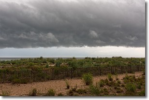
Weather Topic: What are Shelf Clouds?
Home - Education - Cloud Types - Shelf Clouds
 Next Topic: Sleet
A shelf cloud is similar to a wall cloud, but forms at the front
of a storm cloud, instead of at the rear, where wall clouds form.
A shelf cloud is caused by a series of events set into motion by the advancing
storm; first, cool air settles along the ground where precipitation has just fallen.
As the cool air is brought in, the warmer air is displaced, and rises above it,
because it is less dense. When the warmer air reaches the bottom of the storm cloud,
it begins to cool again, and the resulting condensation is a visible shelf cloud.
Next Topic: Sleet
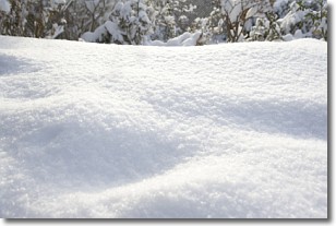
Weather Topic: What is Snow?
Home - Education - Precipitation - Snow
 Next Topic: Stratocumulus Clouds
Snow is precipitation taking the form of ice crystals. Each ice crystal, or snowflake,
has unique characteristics, but all of them grow in a hexagonal structure.
Snowfall can last for sustained periods of time and result in significant buildup
of snow on the ground.
On the earth's surface, snow starts out light and powdery, but as it begins to melt
it tends to become more granular, producing small bits of ice which have the consistency of
sand. After several cycles of melting and freezing, snow can become very dense
and ice-like, commonly known as snow pack.
Next Topic: Stratocumulus Clouds
Current conditions powered by WeatherAPI.com


