Weather Alert in Minnesota
Flood Warning issued August 23 at 9:59AM CDT until August 29 at 7:00PM CDT by NWS Twin Cities/Chanhassen MN
AREAS AFFECTED: Carver, MN; Scott, MN; Sibley, MN
DESCRIPTION: ...The Flood Warning continues for the following rivers in Minnesota... Cottonwood River Above Springfield affecting Brown County. Minnesota River at New Ulm affecting Blue Earth, Nicollet and Brown Counties. Minnesota River at Henderson MN19 affecting Scott, Le Sueur and Sibley Counties. Minnesota River near Jordan affecting Scott, Carver and Sibley Counties. Minnesota River at Granite Falls HWY 212 affecting Yellow Medicine, Renville and Chippewa Counties. Minnesota River at Morton affecting Renville and Redwood Counties. Minnesota River at Montevideo affecting Yellow Medicine, Lac qui Parle and Chippewa Counties. * WHAT...Minor flooding is forecast. * WHERE...Minnesota River near Jordan. * WHEN...From Sunday afternoon to Friday evening. * IMPACTS...At 25.0 feet, Low lying areas and some roads along the river begin to flood and private sanitary sewers may experience problems. * ADDITIONAL DETAILS... - At 845 AM CDT Saturday, the stage was 24.2 feet. - Forecast...The river is expected to rise above flood stage early tomorrow afternoon to a crest of 25.4 feet early Tuesday morning. It will then fall below flood stage early Friday morning. - Flood stage is 25.0 feet.
INSTRUCTION: Turn around, don't drown when encountering flooded roads. Most flood deaths occur in vehicles. Motorists should not attempt to drive around barricades or drive cars through flooded areas. Caution is urged when walking near riverbanks.
Want more detail? Get the Complete 7 Day and Night Detailed Forecast!
Current U.S. National Radar--Current
The Current National Weather Radar is shown below with a UTC Time (subtract 5 hours from UTC to get Eastern Time).

National Weather Forecast--Current
The Current National Weather Forecast and National Weather Map are shown below.

National Weather Forecast for Tomorrow
Tomorrow National Weather Forecast and Tomorrow National Weather Map are show below.

North America Water Vapor (Moisture)
This map shows recent moisture content over North America. Bright and colored areas show high moisture (ie, clouds); brown indicates very little moisture present; black indicates no moisture.

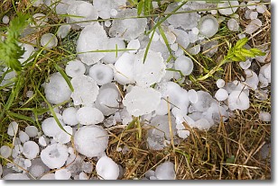
Weather Topic: What is Hail?
Home - Education - Precipitation - Hail
 Next Topic: Hole Punch Clouds
Hail is a form of precipitation which is recognized by large solid balls or
clumps of ice. Hail is created by thunderstorm clouds with strong updrafts of wind.
As the hailstones remain in the updraft, ice is deposited onto them until their
weight becomes heavy enough for them to fall to the earth's surface.
Hail storms can cause significant damage to crops, aircrafts, and man-made structures,
despite the fact that the duration is usually less than ten minutes.
Next Topic: Hole Punch Clouds
Weather Topic: What are Mammatus Clouds?
Home - Education - Cloud Types - Mammatus Clouds
 Next Topic: Nimbostratus Clouds
A mammatus cloud is a cloud with a unique feature which resembles
a web of pouches hanging along the base of the cloud.
In the United States, mammatus clouds tend to form in the warmer months, commonly
in the Midwest and eastern regions.
While they usually form at the bottom of a cumulonimbis cloud, they can also form
under altostratus, altocumulus, stratocumulus, and cirrus clouds. Mammatus clouds
warn that severe weather is close.
Next Topic: Nimbostratus Clouds
Current conditions powered by WeatherAPI.com


