Weather Alert in Montana
Special Weather Statement issued February 25 at 3:30AM MST by NWS Great Falls MT
AREAS AFFECTED: Big Belt, Bridger and Castle Mountains; Meagher County Valleys; Elkhorn and Boulder Mountains; Canyon Ferry Area; Missouri Headwaters; Gallatin Valley; Northwest Beaverhead County; Beaverhead and Western Madison below 6000ft
DESCRIPTION: At 330 AM MST...radar showed showers increasing in coverage across southwest Montana in association with an advancing frontal system. Temperatures are near freezing below 5000 ft where precipitation is mixed but cooling this morning will result in a transition to mostly snow as these showers track across southwest Montana through 7 AM MST. Snow showers will affect areas as far south as Dillon and along the I-90 corridor to Bozeman and Bozeman pass by 6 AM MST. Snow accumulation at elevations below 5000 ft will be minimal, but travelers should expect changing visibility and road conditions in areas affected by these showers. In addition, locally gusty winds near these showers may produce additional visibility reduction.
INSTRUCTION: N/A
Want more detail? Get the Complete 7 Day and Night Detailed Forecast!
Current U.S. National Radar--Current
The Current National Weather Radar is shown below with a UTC Time (subtract 5 hours from UTC to get Eastern Time).

National Weather Forecast--Current
The Current National Weather Forecast and National Weather Map are shown below.

National Weather Forecast for Tomorrow
Tomorrow National Weather Forecast and Tomorrow National Weather Map are show below.

North America Water Vapor (Moisture)
This map shows recent moisture content over North America. Bright and colored areas show high moisture (ie, clouds); brown indicates very little moisture present; black indicates no moisture.

Weather Topic: What is Freezing Rain?
Home - Education - Precipitation - Freezing Rain
 Next Topic: Graupel
Freezing rain is a condition where precipitation which has fallen in the form of
water droplets reaches temperatures which are below freezing and freezes upon
coming into contact
with surface objects. The result of this precipitation is a glaze of ice which
can be damaging to plants and man-made structures. A severe onset of freezing
rain which results in a very thick glaze of ice is known as an ice storm.
Next Topic: Graupel
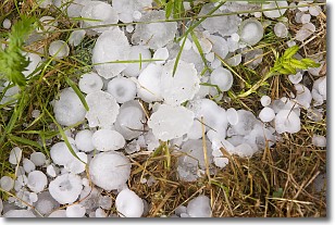
Weather Topic: What is Hail?
Home - Education - Precipitation - Hail
 Next Topic: Hole Punch Clouds
Hail is a form of precipitation which is recognized by large solid balls or
clumps of ice. Hail is created by thunderstorm clouds with strong updrafts of wind.
As the hailstones remain in the updraft, ice is deposited onto them until their
weight becomes heavy enough for them to fall to the earth's surface.
Hail storms can cause significant damage to crops, aircrafts, and man-made structures,
despite the fact that the duration is usually less than ten minutes.
Next Topic: Hole Punch Clouds
Current conditions powered by WeatherAPI.com


