Weather Alert in California
Special Weather Statement issued July 30 at 4:45AM PDT by NWS Eureka CA
AREAS AFFECTED: Northern Humboldt Coast; Southwestern Humboldt; Mendocino Coast
DESCRIPTION: ...TSUNAMI WARNING IS IN EFFECT FOR COASTAL DEL NORTE... ...TSUNAMI ADVISORY IS IN EFFECT FOR THE HUMBOLDT AND DEL NORTE COAST... * UPDATES... The Humboldt County Coast is no longer in a Warning. Tsunami wave impacts are ongoing on the coast but may be starting to lessen. * LOCAL IMPACTS... A tsunami capable of producing strong currents that may be hazardous to swimmers, boats, and coastal structures is expected. Widespread inundation is NOT expected. * RECOMMENDED ACTIONS... If you are located in this coastal area, move off the beach and out of harbors and marinas. Do not go to the coast to watch the tsunami. Be alert to instructions from your local emergency officials * FORECAST TSUNAMI START TIMES... Tsunamis often arrive as a series of waves or surges which could be dangerous for many hours after the first wave arrival. The first tsunami wave or surge may not be the highest in the series. * FORECAST TSUNAMI DURATION... Fort Bragg9 Hours Crescent City30 Hours * FORECAST PEAK TSUNAMI WAVE HEIGHTS... Fort Bragg 0.7 to 1.4 ft Crescent City 2.7 to 5.0 ft Humboldt Bay Around 1 ft. * OBSERVED TSUNAMI WAVE HEIGHTS FROM EARLIER... Tsunami waves are startingto arrive on the West Coast. Up to 3.6 ft observed in Crescent City Up to 1.2 ft observed in Humboldt Bay Up to 3.0 ft observed in Arena Cove * PRELIMINARY EARTHQUAKE INFORMATION... An earthquake occurred with a preliminary magnitude of 8.8. * TIDE INFORMATION... Humboldt Bay North Spit...Low tides of 1.8 ft at 1008 PM PDT on Jul 30, and 2.1 ft at 935 AM PDT on Jul 31. High tides of 6.2 ft at 343 PM PDT on Jul 30, and 4.7 ft at 358 AM PDT on Jul 31. Crescent City Harbor...Low tides of 1.8 ft at 1002 PM PDT on Jul 30, and 2.1 ft at 927 AM PDT on Jul 31. High tides of 6.3 ft at 329 PM PDT on Jul 30, and 4.7 ft at 349 AM PDT on Jul 31. This product will be updated as new information becomes available. Stay tuned to your local news source and NOAA weather radio for further information and updates.
INSTRUCTION: N/A
Want more detail? Get the Complete 7 Day and Night Detailed Forecast!
Current U.S. National Radar--Current
The Current National Weather Radar is shown below with a UTC Time (subtract 5 hours from UTC to get Eastern Time).

National Weather Forecast--Current
The Current National Weather Forecast and National Weather Map are shown below.

National Weather Forecast for Tomorrow
Tomorrow National Weather Forecast and Tomorrow National Weather Map are show below.

North America Water Vapor (Moisture)
This map shows recent moisture content over North America. Bright and colored areas show high moisture (ie, clouds); brown indicates very little moisture present; black indicates no moisture.

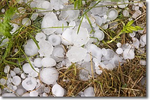
Weather Topic: What is Hail?
Home - Education - Precipitation - Hail
 Next Topic: Hole Punch Clouds
Hail is a form of precipitation which is recognized by large solid balls or
clumps of ice. Hail is created by thunderstorm clouds with strong updrafts of wind.
As the hailstones remain in the updraft, ice is deposited onto them until their
weight becomes heavy enough for them to fall to the earth's surface.
Hail storms can cause significant damage to crops, aircrafts, and man-made structures,
despite the fact that the duration is usually less than ten minutes.
Next Topic: Hole Punch Clouds
Weather Topic: What are Mammatus Clouds?
Home - Education - Cloud Types - Mammatus Clouds
 Next Topic: Nimbostratus Clouds
A mammatus cloud is a cloud with a unique feature which resembles
a web of pouches hanging along the base of the cloud.
In the United States, mammatus clouds tend to form in the warmer months, commonly
in the Midwest and eastern regions.
While they usually form at the bottom of a cumulonimbis cloud, they can also form
under altostratus, altocumulus, stratocumulus, and cirrus clouds. Mammatus clouds
warn that severe weather is close.
Next Topic: Nimbostratus Clouds
Current conditions powered by WeatherAPI.com


