Weather Alert in Wisconsin
Winter Weather Advisory issued April 1 at 1:39AM CDT until April 2 at 10:00AM CDT by NWS La Crosse WI
AREAS AFFECTED: Trempealeau; Jackson; Monroe; Juneau; Adams
DESCRIPTION: ...LATE WINTER STORM IMPACTS THE AREA FROM TONIGHT THROUGH THURSDAY MORNING... .A late season winter storm will impact areas along and north of Interstate 90 from this evening into Thursday morning. Snow, sleet, and freezing rain will begin late this evening, changing to freezing rain overnight. Ice accumulations are expected and will continue into Thursday morning. Temperatures will warm Thursday afternoon and only rain will be expected. Travel is expected to be impacted. * WHAT...Mixed precipitation expected. Total snow and sleet accumulations up to one inch and ice accumulations up to a quarter inch. * WHERE...Adams, Juneau, Jackson, Monroe, and Trempealeau Counties. * WHEN...From midnight tonight to 10 AM CDT Thursday. * IMPACTS...Power outages and tree damage are possible due to the ice. The hazardous conditions could impact the Thursday morning commute.
INSTRUCTION: Slow down and use caution while traveling. Visit 511wi.gov for road conditions.
Want more detail? Get the Complete 7 Day and Night Detailed Forecast!
Current U.S. National Radar--Current
The Current National Weather Radar is shown below with a UTC Time (subtract 5 hours from UTC to get Eastern Time).

National Weather Forecast--Current
The Current National Weather Forecast and National Weather Map are shown below.

National Weather Forecast for Tomorrow
Tomorrow National Weather Forecast and Tomorrow National Weather Map are show below.

North America Water Vapor (Moisture)
This map shows recent moisture content over North America. Bright and colored areas show high moisture (ie, clouds); brown indicates very little moisture present; black indicates no moisture.

Weather Topic: What is Freezing Rain?
Home - Education - Precipitation - Freezing Rain
 Next Topic: Graupel
Freezing rain is a condition where precipitation which has fallen in the form of
water droplets reaches temperatures which are below freezing and freezes upon
coming into contact
with surface objects. The result of this precipitation is a glaze of ice which
can be damaging to plants and man-made structures. A severe onset of freezing
rain which results in a very thick glaze of ice is known as an ice storm.
Next Topic: Graupel
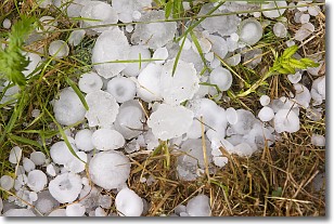
Weather Topic: What is Hail?
Home - Education - Precipitation - Hail
 Next Topic: Hole Punch Clouds
Hail is a form of precipitation which is recognized by large solid balls or
clumps of ice. Hail is created by thunderstorm clouds with strong updrafts of wind.
As the hailstones remain in the updraft, ice is deposited onto them until their
weight becomes heavy enough for them to fall to the earth's surface.
Hail storms can cause significant damage to crops, aircrafts, and man-made structures,
despite the fact that the duration is usually less than ten minutes.
Next Topic: Hole Punch Clouds
Current conditions powered by WeatherAPI.com


