Weather Alert in New Mexico
Flood Advisory issued September 6 at 9:37PM MDT until September 7 at 12:30AM MDT by NWS Albuquerque NM
AREAS AFFECTED: Bernalillo, NM; Valencia, NM
DESCRIPTION: * WHAT...Arroyo and small stream flooding caused by excessive rainfall is expected. * WHERE...A portion of central New Mexico, including the following counties, Bernalillo and northeastern Valencia. * WHEN...Until 1230 AM MDT. * IMPACTS...Minor flooding in low-lying and poor drainage areas. * ADDITIONAL DETAILS... - At 936 PM MDT, Doppler radar indicated heavy rain due to thunderstorms. This will cause arroyo and small stream flooding. Up to 1.75 inches of rain have fallen. - Additional rainfall amounts up to 1 inch are expected over the area. The potential exists for flash flooding to develop. - Some locations that will experience flooding include... Los Lunas, Belen, Valencia, Bosque Farms, Meadow Lake, El Cerro Mission, Isleta Pueblo, Rio Communities North, Tome and Los Chaves. - http://www.weather.gov/safety/flood
INSTRUCTION: Be especially cautious at night when it is harder to recognize the dangers of flooding. Both localized and distant heavy rainfall will create sudden and dangerous flows in arroyos and over low water crossings.
Want more detail? Get the Complete 7 Day and Night Detailed Forecast!
Current U.S. National Radar--Current
The Current National Weather Radar is shown below with a UTC Time (subtract 5 hours from UTC to get Eastern Time).

National Weather Forecast--Current
The Current National Weather Forecast and National Weather Map are shown below.

National Weather Forecast for Tomorrow
Tomorrow National Weather Forecast and Tomorrow National Weather Map are show below.

North America Water Vapor (Moisture)
This map shows recent moisture content over North America. Bright and colored areas show high moisture (ie, clouds); brown indicates very little moisture present; black indicates no moisture.

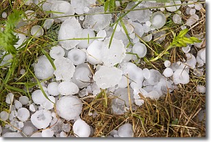
Weather Topic: What is Hail?
Home - Education - Precipitation - Hail
 Next Topic: Hole Punch Clouds
Hail is a form of precipitation which is recognized by large solid balls or
clumps of ice. Hail is created by thunderstorm clouds with strong updrafts of wind.
As the hailstones remain in the updraft, ice is deposited onto them until their
weight becomes heavy enough for them to fall to the earth's surface.
Hail storms can cause significant damage to crops, aircrafts, and man-made structures,
despite the fact that the duration is usually less than ten minutes.
Next Topic: Hole Punch Clouds
Weather Topic: What are Mammatus Clouds?
Home - Education - Cloud Types - Mammatus Clouds
 Next Topic: Nimbostratus Clouds
A mammatus cloud is a cloud with a unique feature which resembles
a web of pouches hanging along the base of the cloud.
In the United States, mammatus clouds tend to form in the warmer months, commonly
in the Midwest and eastern regions.
While they usually form at the bottom of a cumulonimbis cloud, they can also form
under altostratus, altocumulus, stratocumulus, and cirrus clouds. Mammatus clouds
warn that severe weather is close.
Next Topic: Nimbostratus Clouds
Current conditions powered by WeatherAPI.com


