Weather Alert in Alaska
Flood Watch issued August 25 at 1:48PM AKDT until August 28 at 10:00AM AKDT by NWS Anchorage AK
AREAS AFFECTED: Western Capes
DESCRIPTION: * WHAT...Flooding caused by excessive rainfall continues to be possible. * WHERE...Western Capes * WHEN...Through Thursday morning. * IMPACTS...Excessive rainfall and runoff may result in flooding of small streams, and other low-lying and flood-prone locations. Significant ponding of water, areal flooding, and erosion may occur in poor drainage areas. Flooding is not expected along the main Kuskokwim River and other major rivers. * ADDITIONAL DETAILS... - An atmospheric river will bring prolonged, widespread rainfall across Southwest Alaska this week. Steadier rainfall, which can be moderate to heavy at times, is expected to begin Monday and last through at least Wednesday with showers lingering through the rest of the week. Widespread rainfall totals of 1.5 to 3 inches is expected with locally higher amounts possible. This includes the communities around the Bethel area through Crooked Creek, the Western Capes, and the Dillingham to Aleknagik area. The highest rainfall totals of at least 2.5 to 4 inches is expected close to the mountains near Togiak and the Western Capes. - Http://www.weather.gov/safety/flood
INSTRUCTION: You should monitor later forecasts and be alert for possible Flood Warnings. Those living in areas prone to flooding should be prepared to take action should flooding develop.
Want more detail? Get the Complete 7 Day and Night Detailed Forecast!
Current U.S. National Radar--Current
The Current National Weather Radar is shown below with a UTC Time (subtract 5 hours from UTC to get Eastern Time).

National Weather Forecast--Current
The Current National Weather Forecast and National Weather Map are shown below.

National Weather Forecast for Tomorrow
Tomorrow National Weather Forecast and Tomorrow National Weather Map are show below.

North America Water Vapor (Moisture)
This map shows recent moisture content over North America. Bright and colored areas show high moisture (ie, clouds); brown indicates very little moisture present; black indicates no moisture.

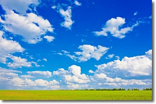
Weather Topic: What are Cumulus Clouds?
Home - Education - Cloud Types - Cumulus Clouds
 Next Topic: Drizzle
Cumulus clouds are fluffy and textured with rounded tops, and
may have flat bottoms. The border of a cumulus cloud
is clearly defined, and can have the appearance of cotton or cauliflower.
Cumulus clouds form at low altitudes (rarely above 2 km) but can grow very tall,
becoming cumulus congestus and possibly the even taller cumulonimbus clouds.
When cumulus clouds become taller, they have a greater chance of producing precipitation.
Next Topic: Drizzle
Weather Topic: What is Evaporation?
Home - Education - Precipitation - Evaporation
 Next Topic: Fog
Evaporation is the process which returns water from the earth
back to the atmosphere, and is another crucial process in the water cycle.
Evaporation is the transformation of liquid into gas, and it happens because
molecules are excited by the application of energy and turn into vapor.
In order for water to evaporate it has to be on the surface of a body of water.
Next Topic: Fog
Current conditions powered by WeatherAPI.com


