Weather Alert in Alaska
Heat Advisory issued August 25 at 1:48PM AKDT until August 25 at 7:00PM AKDT by NWS Juneau AK
AREAS AFFECTED: City of Hyder
DESCRIPTION: * WHAT...High temperatures into the lower 80s are expected. * WHERE...City of Hyder. * WHEN...Until 7 PM AKDT Monday. * IMPACTS...Individuals not accustomed to these unusually warm temperatures for this region may experience heat related illnesses. * ADDITIONAL DETAILS...These temperatures will occur during the afternoon & into the evening hours. The warmest temperatures will be in areas farthest away from the water away from any significant sea breeze influence.
INSTRUCTION: Drink plenty of fluids, check up on our elders, and especially check up on people you know who may be vulnerable to heat stress due to pre-existing health concerns. Young children and pets should never be left unattended in vehicles under any circumstances as vehicle interiors can reach extreme temperatures in as little as 10 minutes. Take extra precautions when working in the sun. Wear lightweight, loose fitting clothing. Try to limit strenuous activities to early morning or evening. Take action when you see symptoms of heat exhaustion and heat stroke. Close curtains during the daytime to reduce insolation into the home and open windows at night to allow the home to cool off. Utilize fans or community buildings with air conditioning.
Want more detail? Get the Complete 7 Day and Night Detailed Forecast!
Current U.S. National Radar--Current
The Current National Weather Radar is shown below with a UTC Time (subtract 5 hours from UTC to get Eastern Time).

National Weather Forecast--Current
The Current National Weather Forecast and National Weather Map are shown below.

National Weather Forecast for Tomorrow
Tomorrow National Weather Forecast and Tomorrow National Weather Map are show below.

North America Water Vapor (Moisture)
This map shows recent moisture content over North America. Bright and colored areas show high moisture (ie, clouds); brown indicates very little moisture present; black indicates no moisture.

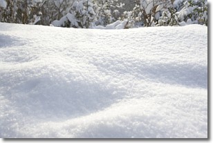
Weather Topic: What is Snow?
Home - Education - Precipitation - Snow
 Next Topic: Stratocumulus Clouds
Snow is precipitation taking the form of ice crystals. Each ice crystal, or snowflake,
has unique characteristics, but all of them grow in a hexagonal structure.
Snowfall can last for sustained periods of time and result in significant buildup
of snow on the ground.
On the earth's surface, snow starts out light and powdery, but as it begins to melt
it tends to become more granular, producing small bits of ice which have the consistency of
sand. After several cycles of melting and freezing, snow can become very dense
and ice-like, commonly known as snow pack.
Next Topic: Stratocumulus Clouds
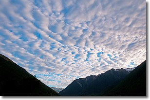
Weather Topic: What are Stratus Clouds?
Home - Education - Cloud Types - Stratus Clouds
 Next Topic: Wall Clouds
Stratus clouds are similar to altostratus clouds, but form at a
lower altitude and are identified by their fog-like appearance, lacking the
distinguishing features of most clouds.
Stratus clouds are wider than most clouds, and their base has a smooth, uniform
look which is lighter in color than a nimbostratus cloud.
The presence of a stratus cloud indicates the possibility of minor precipitation,
such as drizzle, but heavier precipitation does not typically arrive in the form
of a stratus cloud.
Next Topic: Wall Clouds
Current conditions powered by WeatherAPI.com


