Weather Alert in New Mexico
Flood Watch issued August 26 at 11:10AM MDT until August 27 at 12:00AM MDT by NWS Albuquerque NM
AREAS AFFECTED: Southern Sangre de Cristo Mountains; East Slopes Sangre de Cristo Mountains; South Central Mountains; Northeast Highlands
DESCRIPTION: * WHAT...Flash flooding caused by excessive rainfall continues to be possible. * WHERE...Portions of central, north central, and northeast New Mexico, including the following areas, in central New Mexico, South Central Mountains. In north central New Mexico, East Slopes Sangre de Cristo Mountains and Southern Sangre de Cristo Mountains. In northeast New Mexico, Northeast Highlands. * WHEN...Through this evening. * IMPACTS...Excessive runoff may result in flooding of rivers, creeks, streams, and other low-lying and flood-prone locations. Creeks and streams may rise out of their banks. Storm drains and ditches may become clogged with debris. * ADDITIONAL DETAILS... - Numerous thunderstorms will develop over the northern mountains this afternoon and evening, with scattered to numerous coverage of storms over the south central mountains. Some of the stronger storms will be capable of producing rain at rates over 1 inch per hour, and some locations may receive multiple storms. Locations where the ground is already saturated from heavy rainfall, recent burn scars, and urban areas will be especially susceptible to rapid runoff and flash flooding. On Monday, the western third of the San Miguel County part of the Hermits Peak Calf Canyon scar accumulated 1 to 2 inches of rainfall, so rapid runoff is likely there today. - http://www.weather.gov/safety/flood
INSTRUCTION: Turn around, don't drown when encountering flooded roads. Most flood deaths occur in vehicles.
Want more detail? Get the Complete 7 Day and Night Detailed Forecast!
Current U.S. National Radar--Current
The Current National Weather Radar is shown below with a UTC Time (subtract 5 hours from UTC to get Eastern Time).

National Weather Forecast--Current
The Current National Weather Forecast and National Weather Map are shown below.

National Weather Forecast for Tomorrow
Tomorrow National Weather Forecast and Tomorrow National Weather Map are show below.

North America Water Vapor (Moisture)
This map shows recent moisture content over North America. Bright and colored areas show high moisture (ie, clouds); brown indicates very little moisture present; black indicates no moisture.

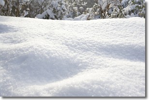
Weather Topic: What is Snow?
Home - Education - Precipitation - Snow
 Next Topic: Stratocumulus Clouds
Snow is precipitation taking the form of ice crystals. Each ice crystal, or snowflake,
has unique characteristics, but all of them grow in a hexagonal structure.
Snowfall can last for sustained periods of time and result in significant buildup
of snow on the ground.
On the earth's surface, snow starts out light and powdery, but as it begins to melt
it tends to become more granular, producing small bits of ice which have the consistency of
sand. After several cycles of melting and freezing, snow can become very dense
and ice-like, commonly known as snow pack.
Next Topic: Stratocumulus Clouds
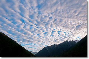
Weather Topic: What are Stratus Clouds?
Home - Education - Cloud Types - Stratus Clouds
 Next Topic: Wall Clouds
Stratus clouds are similar to altostratus clouds, but form at a
lower altitude and are identified by their fog-like appearance, lacking the
distinguishing features of most clouds.
Stratus clouds are wider than most clouds, and their base has a smooth, uniform
look which is lighter in color than a nimbostratus cloud.
The presence of a stratus cloud indicates the possibility of minor precipitation,
such as drizzle, but heavier precipitation does not typically arrive in the form
of a stratus cloud.
Next Topic: Wall Clouds
Current conditions powered by WeatherAPI.com


