Weather Alert in North Carolina
Flood Advisory issued August 2 at 4:47PM EDT until August 2 at 7:15PM EDT by NWS Greenville-Spartanburg SC
AREAS AFFECTED: Haywood, NC
DESCRIPTION: * WHAT...Small stream flooding caused by excessive rainfall is expected. * WHERE...A portion of western North Carolina, including the following county, Haywood. * WHEN...Until 715 PM EDT. * IMPACTS...Minor flooding in low-lying and poor drainage areas. River or stream flows are elevated. * ADDITIONAL DETAILS... - At 436 PM EDT, Doppler radar indicated heavy rain due to thunderstorms. Minor flooding is ongoing or expected to begin shortly in the Advisory area. Between 1 and 3 inches of rain has fallen over the area with additional rain likely over the next few hours. - This includes the following streams and drainages... Cataloochee Creek, Cold Springs creek, Gunter Fork, Pigeon River, Spring Creek, Hurricane Creek, Chestnut Branch, Andy Branch, Little Cataloochee Creek, Lost Bottom Creek, Big Creek, Dry Branch, Mouse Creek, Dogwood Flats Creek, Balsam Corner Creek, Laurel Branch, Palmer Creek and Mount Sterling Creek. - http://www.weather.gov/safety/flood
INSTRUCTION: When it is safe to do so, please report flooding or landslides threatening roads or property to the National Weather Service Greenville-Spartanburg by calling toll free, 1, 800, 2 6 7, 8 1 0 1, by posting on our Facebook page, or via X using hashtag NWSGSP. Your message should describe the specific location where impacts occurred and the depth of flooding observed.
Want more detail? Get the Complete 7 Day and Night Detailed Forecast!
Current U.S. National Radar--Current
The Current National Weather Radar is shown below with a UTC Time (subtract 5 hours from UTC to get Eastern Time).

National Weather Forecast--Current
The Current National Weather Forecast and National Weather Map are shown below.

National Weather Forecast for Tomorrow
Tomorrow National Weather Forecast and Tomorrow National Weather Map are show below.

North America Water Vapor (Moisture)
This map shows recent moisture content over North America. Bright and colored areas show high moisture (ie, clouds); brown indicates very little moisture present; black indicates no moisture.

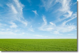
Weather Topic: What are Cirrus Clouds?
Home - Education - Cloud Types - Cirrus Clouds
 Next Topic: Condensation
Cirrus clouds are high-level clouds that occur above 20,000 feet
and are composed mainly of ice crystals.
They are thin and wispy in appearance.
What do they indicate?
They are often the first sign of an approaching storm.
Next Topic: Condensation
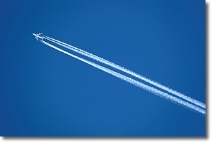
Weather Topic: What are Contrails?
Home - Education - Cloud Types - Contrails
 Next Topic: Cumulonimbus Clouds
A contrail is an artificial cloud, created by the passing of an
aircraft.
Contrails form because water vapor in the exhaust of aircraft engines is suspended
in the air under certain temperatures and humidity conditions. These contrails
are called exhaust contrails.
Another type of contrail can form due to a temporary reduction in air pressure
moving over the plane's surface, causing condensation.
These are called aerodynamic contrails.
When you can see your breath on a cold day, it is also because of condensation.
The reason contrails last longer than the condensation from your breath is
because the water in contrails freezes into ice particles.
Next Topic: Cumulonimbus Clouds
Current conditions powered by WeatherAPI.com


