Weather Alert in Wyoming
Avalanche Warning issued February 24 at 8:07PM MST by NWS Riverton WY
AREAS AFFECTED: Star Valley; Salt River and Wyoming Ranges
DESCRIPTION: AVWRIW * WHAT...High avalanche danger has developed due to heavy rates of snowfall and intense wind. * WHERE...The mountains of Western Wyoming including the Tetons, Snake River, Salt River, and Wyoming Ranges. The mountains of southeast Idaho including the Snake River Range, Caribou Range, and Big Holes. * WHEN...In effect from Tue 22:00 MST to Wed 22:00 MST. * IMPACTS...Heavy snowfall combined with strong wind will create widespread areas of unstable snow and overload buried weak layers. Natural and human-triggered avalanches will be very likely across all aspects above 7,000' for backcountry recreationalists. * PRECAUTIONARY / PREPAREDNESS ACTIONS...Very dangerous avalanche conditions. Travel in avalanche terrain is not recommended. Gentle terrain below large avalanche paths could be impacted. Consult http://bridgertetonavalanchecenter.org/ or www.avalanche.org for more detailed information. Similar avalanche danger may exist at locations outside the coverage area of this or any avalanche center. Consult bridgertetonavalanchecenter.org or avalanche.org for more detailed information. Similar avalanche danger may exist at locations outside the coverage area of this or any avalanche center.
INSTRUCTION: N/A
Want more detail? Get the Complete 7 Day and Night Detailed Forecast!
Current U.S. National Radar--Current
The Current National Weather Radar is shown below with a UTC Time (subtract 5 hours from UTC to get Eastern Time).

National Weather Forecast--Current
The Current National Weather Forecast and National Weather Map are shown below.

National Weather Forecast for Tomorrow
Tomorrow National Weather Forecast and Tomorrow National Weather Map are show below.

North America Water Vapor (Moisture)
This map shows recent moisture content over North America. Bright and colored areas show high moisture (ie, clouds); brown indicates very little moisture present; black indicates no moisture.

Weather Topic: What is Freezing Rain?
Home - Education - Precipitation - Freezing Rain
 Next Topic: Graupel
Freezing rain is a condition where precipitation which has fallen in the form of
water droplets reaches temperatures which are below freezing and freezes upon
coming into contact
with surface objects. The result of this precipitation is a glaze of ice which
can be damaging to plants and man-made structures. A severe onset of freezing
rain which results in a very thick glaze of ice is known as an ice storm.
Next Topic: Graupel
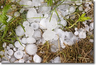
Weather Topic: What is Hail?
Home - Education - Precipitation - Hail
 Next Topic: Hole Punch Clouds
Hail is a form of precipitation which is recognized by large solid balls or
clumps of ice. Hail is created by thunderstorm clouds with strong updrafts of wind.
As the hailstones remain in the updraft, ice is deposited onto them until their
weight becomes heavy enough for them to fall to the earth's surface.
Hail storms can cause significant damage to crops, aircrafts, and man-made structures,
despite the fact that the duration is usually less than ten minutes.
Next Topic: Hole Punch Clouds
Current conditions powered by WeatherAPI.com


