Weather Alert in California
Special Weather Statement issued July 30 at 6:39AM PDT by NWS Eureka CA
AREAS AFFECTED: Northern Humboldt Coast; Southwestern Humboldt; Mendocino Coast
DESCRIPTION: ...TSUNAMI WARNING IS IN EFFECT FOR COASTAL DEL NORTE... ...TSUNAMI ADVISORY IS IN EFFECT FOR THE HUMBOLDT AND MENDOCINO COAST... * UPDATES... Signifcant Tsunami waves continue to be observed along the coast with heights between 1 and 2 feet. Activity appears to be slowly decreasing. * LOCAL IMPACTS... A tsunami capable of producing strong currents that may be hazardous to swimmers, boats, and coastal structures is expected. Widespread inundation is NOT expected. * RECOMMENDED ACTIONS... If you are located in this coastal area, move off the beach and out of harbors and marinas. Do not go to the coast to watch the tsunami. Be alert to instructions from your local emergency officials * FORECAST TSUNAMI START TIMES... Tsunamis often arrive as a series of waves or surges which could be dangerous for many hours after the first wave arrival. The first tsunami wave or surge may not be the highest in the series. * FORECAST TSUNAMI DURATION... Fort Bragg3 Hours Crescent City23 Hours * FORECAST PEAK TSUNAMI WAVE HEIGHTS... Fort Bragg 0.7 to 1.4 ft Crescent City 2.7 to 5.0 ft Humboldt Bay Around 1 ft. * OBSERVED TSUNAMI WAVE HEIGHTS FROM EARLIER... Tsunami waves are startingto arrive on the West Coast. Up to 4.0 ft observed in Crescent City Up to 1.2 ft observed in Humboldt Bay Up to 3.0 ft observed in Arena Cove * PRELIMINARY EARTHQUAKE INFORMATION... An earthquake occurred with a preliminary magnitude of 8.8. * TIDE INFORMATION... Humboldt Bay North Spit...Low tides of 1.8 ft at 1008 PM PDT on Jul 30, and 2.1 ft at 935 AM PDT on Jul 31. High tides of 6.2 ft at 343 PM PDT on Jul 30, and 4.7 ft at 358 AM PDT on Jul 31. Crescent City Harbor...Low tides of 1.8 ft at 1002 PM PDT on Jul 30, and 2.1 ft at 927 AM PDT on Jul 31. High tides of 6.3 ft at 329 PM PDT on Jul 30, and 4.7 ft at 349 AM PDT on Jul 31. This product will be updated as new information becomes available. Stay tuned to your local news source and NOAA weather radio for further information and updates.
INSTRUCTION: N/A
Want more detail? Get the Complete 7 Day and Night Detailed Forecast!
Current U.S. National Radar--Current
The Current National Weather Radar is shown below with a UTC Time (subtract 5 hours from UTC to get Eastern Time).

National Weather Forecast--Current
The Current National Weather Forecast and National Weather Map are shown below.

National Weather Forecast for Tomorrow
Tomorrow National Weather Forecast and Tomorrow National Weather Map are show below.

North America Water Vapor (Moisture)
This map shows recent moisture content over North America. Bright and colored areas show high moisture (ie, clouds); brown indicates very little moisture present; black indicates no moisture.

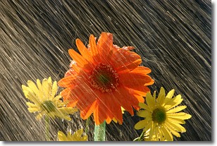
Weather Topic: What is Precipitation?
Home - Education - Precipitation - Precipitation
 Next Topic: Rain
Precipitation can refer to many different forms of water that
may fall from clouds. Precipitation occurs after a cloud has become saturated to
the point where its water particles are more dense than the air below the cloud.
In most cases, precipitation will reach the ground, but it is not uncommon for
precipitation to evaporate before it reaches the earth's surface.
When precipitation evaporates before it contacts the ground it is called Virga.
Graupel, hail, sleet, rain, drizzle, and snow are forms of precipitation, but fog
and mist are not considered precipitation because the water vapor which
constitutes them isn't dense enough to fall to the ground.
Next Topic: Rain
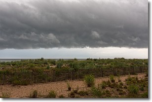
Weather Topic: What are Shelf Clouds?
Home - Education - Cloud Types - Shelf Clouds
 Next Topic: Sleet
A shelf cloud is similar to a wall cloud, but forms at the front
of a storm cloud, instead of at the rear, where wall clouds form.
A shelf cloud is caused by a series of events set into motion by the advancing
storm; first, cool air settles along the ground where precipitation has just fallen.
As the cool air is brought in, the warmer air is displaced, and rises above it,
because it is less dense. When the warmer air reaches the bottom of the storm cloud,
it begins to cool again, and the resulting condensation is a visible shelf cloud.
Next Topic: Sleet
Current conditions powered by WeatherAPI.com


