Weather Alert in North Carolina
Flood Advisory issued August 13 at 10:18AM EDT until August 13 at 11:30AM EDT by NWS Raleigh NC
AREAS AFFECTED: Harnett, NC; Lee, NC; Montgomery, NC; Moore, NC; Richmond, NC
DESCRIPTION: * WHAT...Flooding caused by excessive rainfall continues. * WHERE...A portion of central North Carolina, including the following counties, Harnett, Lee, Montgomery, Moore and Richmond. * WHEN...Until 1130 AM EDT. * IMPACTS...Minor flooding in low-lying and poor drainage areas. Ponding of water in urban or other areas is occurring or is imminent. * ADDITIONAL DETAILS... - At 1017 AM EDT, The bulk of the heavy rain is moving out of the warned area. However, creeks and streams remain elevated from rain over the last 3 to 6 hours. Minor flooding is ongoing or expected to begin shortly in the advisory area. Between 2 and 4 inches of rain have fallen. - Some locations that will experience flooding include... Sanford, Southern Pines, Troy, Carthage, Pinehurst, Biscoe, Whispering Pines, Broadway, Robbins, Foxfire, Star, Candor, Taylortown, Vass, Cameron, Norman, Seven Lakes, Eagle Springs, Derby and Tramway. - http://www.weather.gov/safety/flood
INSTRUCTION: Turn around, don't drown when encountering flooded roads. Most flood deaths occur in vehicles.
Want more detail? Get the Complete 7 Day and Night Detailed Forecast!
Current U.S. National Radar--Current
The Current National Weather Radar is shown below with a UTC Time (subtract 5 hours from UTC to get Eastern Time).

National Weather Forecast--Current
The Current National Weather Forecast and National Weather Map are shown below.

National Weather Forecast for Tomorrow
Tomorrow National Weather Forecast and Tomorrow National Weather Map are show below.

North America Water Vapor (Moisture)
This map shows recent moisture content over North America. Bright and colored areas show high moisture (ie, clouds); brown indicates very little moisture present; black indicates no moisture.

Weather Topic: What is Freezing Rain?
Home - Education - Precipitation - Freezing Rain
 Next Topic: Graupel
Freezing rain is a condition where precipitation which has fallen in the form of
water droplets reaches temperatures which are below freezing and freezes upon
coming into contact
with surface objects. The result of this precipitation is a glaze of ice which
can be damaging to plants and man-made structures. A severe onset of freezing
rain which results in a very thick glaze of ice is known as an ice storm.
Next Topic: Graupel
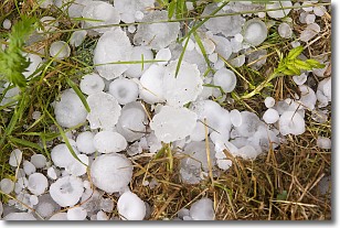
Weather Topic: What is Hail?
Home - Education - Precipitation - Hail
 Next Topic: Hole Punch Clouds
Hail is a form of precipitation which is recognized by large solid balls or
clumps of ice. Hail is created by thunderstorm clouds with strong updrafts of wind.
As the hailstones remain in the updraft, ice is deposited onto them until their
weight becomes heavy enough for them to fall to the earth's surface.
Hail storms can cause significant damage to crops, aircrafts, and man-made structures,
despite the fact that the duration is usually less than ten minutes.
Next Topic: Hole Punch Clouds
Current conditions powered by WeatherAPI.com


