Weather Alert in North Carolina
Flood Advisory issued August 11 at 1:26PM EDT until August 11 at 7:15PM EDT by NWS Greenville-Spartanburg SC
AREAS AFFECTED: Gaston, NC
DESCRIPTION: * WHAT...Flooding caused by excessive rainfall is expected. * WHERE...A portion of piedmont North Carolina, including the following county, Gaston. * WHEN...Until 415 PM EDT. * IMPACTS...Nuisance flooding of low-lying areas adjacent to streams and other poor-drainage areas, including farmland, parks, greenways, boat-access areas, golf courses, underpasses, and parking lots. Isolated, shallow flows over roadways is possible. A few flood-prone, low-water crossings may become impassible. A small culvert washout or two is possible. * ADDITIONAL DETAILS... - At 109 PM EDT, Doppler radar and automated rain gauges indicate heavy rainfall is gradually tapering off from south to north from Crowders to Gastonia, Ranlo, and Dallas across central and southern Gaston County. However, rainfall totals of 1-2 inches have been observed over the past 30-45 minutes, which is heavy enough to result in excessive runoff and rapidly rising smaller streams. Developing areas of nuisance flooding, especially within the city of Gastonia, are possible over the next 60 minutes. Areas of greatest concern include, but are not limited to: 1) Catawba Creek from W Garrison Blvd to S Marietta St to Ferguson Park and the Catawba Creek Golf Course, to Union Rd and Fern Forest Dr along the Catawba Creek Greenway. 2) Blackwood Creek near All American Park and from S Linwood Rd to Old West Ln to Davis Park Rd. 3) Kaglor Branch near W Davidson Ave, Tulip Dr, and Rankin Lake Park. - Moderate to heavy rainfall is expected to persist for the next 15 minutes before tapering off. This may result in another half-inch to inch of rainfall. However, additional moderate to heavy rainfall is possible into the later afternoon hours. Given antecedent conditions, if additional rainfall develops, more significant flash flooding may occur and a Flash Flood Warning may be issued. Caution is advised near any stream or other vulnerable area. Seek higher ground immediately if heavy rain develops. Please have a plan in place should flash flooding develop and do not hesitate to act. - Some locations that may experience nuisance flooding include... Gastonia, Bessemer City, South Gastonia, Dallas, Cramerton, Lowell, Ranlo, Lake Wylie and Crowders. - Http://www.weather.gov/safety/flood
INSTRUCTION: Move to higher ground now. Act quickly to protect your life. Be aware of your surroundings and do not drive on flooded roads. Stay away or be swept away. River banks and culverts can become unstable and unsafe.
Want more detail? Get the Complete 7 Day and Night Detailed Forecast!
Current U.S. National Radar--Current
The Current National Weather Radar is shown below with a UTC Time (subtract 5 hours from UTC to get Eastern Time).

National Weather Forecast--Current
The Current National Weather Forecast and National Weather Map are shown below.

National Weather Forecast for Tomorrow
Tomorrow National Weather Forecast and Tomorrow National Weather Map are show below.

North America Water Vapor (Moisture)
This map shows recent moisture content over North America. Bright and colored areas show high moisture (ie, clouds); brown indicates very little moisture present; black indicates no moisture.

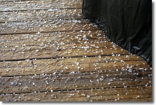
Weather Topic: What is Sleet?
Home - Education - Precipitation - Sleet
 Next Topic: Snow
Sleet is a form of precipitation in which small ice pellets are the primary
components. These ice pellets are smaller and more translucent than hailstones,
and harder than graupel. Sleet is caused by specific atmospheric conditions and
therefore typically doesn't last for extended periods of time.
The condition which leads to sleet formation requires a warmer body of air to be
wedged in between two sub-freezing bodies of air. When snow falls through a warmer
layer of air it melts, and as it falls through the next sub-freezing body of air
it freezes again, forming ice pellets known as sleet. In some cases, water
droplets don't have time to freeze before reaching the surface and the result is
freezing rain.
Next Topic: Snow
Weather Topic: What are Stratocumulus Clouds?
Home - Education - Cloud Types - Stratocumulus Clouds
 Next Topic: Stratus Clouds
Stratocumulus clouds are similar to altocumulus clouds in their
fluffy appearance, but have a slightly darker shade due to their additional mass.
A good way to distinguish the two cloud types is to hold your hand out and measure
the size of an individual cloud; if it is the size of your thumb it is generally
an altocumulus cloud, if it is the size of your hand it is generally a
stratocumulus cloud.
It is uncommon for stratocumulus clouds to produce precipitation, but if they do
it is usually a light rain or snow.
Next Topic: Stratus Clouds
Current conditions powered by WeatherAPI.com


