Weather Alert in Michigan
Special Weather Statement issued February 25 at 4:43AM EST by NWS Gaylord MI
AREAS AFFECTED: Emmet; Cheboygan; Presque Isle; Leelanau; Antrim; Otsego; Montmorency; Benzie; Grand Traverse; Kalkaska; Crawford; Oscoda; Manistee; Wexford; Missaukee; Roscommon; Western Chippewa; Central Chippewa; Western Mackinac; Beaver Island and surrounding islands; Charlevoix
DESCRIPTION: Commutes this morning will be impacted by lake effect snow showers across much of northern lower and eastern upper Michigan. Reduced visibility (at times below one mile) from falling and blowing snow is likely along with snow-covered roads... both from snow yesterday evening and snow actively falling. Be sure to give yourself some extra time for the morning commute, and increase your following distance between yourself and the vehicle in front of you. When encountering reduced visibility, be sure to utilize low-beam headlights in order to make yourself more visible to other motorists.
INSTRUCTION: N/A
Want more detail? Get the Complete 7 Day and Night Detailed Forecast!
Current U.S. National Radar--Current
The Current National Weather Radar is shown below with a UTC Time (subtract 5 hours from UTC to get Eastern Time).

National Weather Forecast--Current
The Current National Weather Forecast and National Weather Map are shown below.

National Weather Forecast for Tomorrow
Tomorrow National Weather Forecast and Tomorrow National Weather Map are show below.

North America Water Vapor (Moisture)
This map shows recent moisture content over North America. Bright and colored areas show high moisture (ie, clouds); brown indicates very little moisture present; black indicates no moisture.

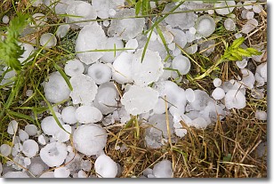
Weather Topic: What is Hail?
Home - Education - Precipitation - Hail
 Next Topic: Hole Punch Clouds
Hail is a form of precipitation which is recognized by large solid balls or
clumps of ice. Hail is created by thunderstorm clouds with strong updrafts of wind.
As the hailstones remain in the updraft, ice is deposited onto them until their
weight becomes heavy enough for them to fall to the earth's surface.
Hail storms can cause significant damage to crops, aircrafts, and man-made structures,
despite the fact that the duration is usually less than ten minutes.
Next Topic: Hole Punch Clouds
Weather Topic: What are Mammatus Clouds?
Home - Education - Cloud Types - Mammatus Clouds
 Next Topic: Nimbostratus Clouds
A mammatus cloud is a cloud with a unique feature which resembles
a web of pouches hanging along the base of the cloud.
In the United States, mammatus clouds tend to form in the warmer months, commonly
in the Midwest and eastern regions.
While they usually form at the bottom of a cumulonimbis cloud, they can also form
under altostratus, altocumulus, stratocumulus, and cirrus clouds. Mammatus clouds
warn that severe weather is close.
Next Topic: Nimbostratus Clouds
Current conditions powered by WeatherAPI.com


