Weather Alert in Illinois
Flood Warning issued April 18 at 9:24PM CDT until April 23 at 4:00PM CDT by NWS Paducah KY
AREAS AFFECTED: Pulaski, IL; Ballard, KY
DESCRIPTION: ...The Flood Warning continues for the following rivers in Illinois...Kentucky...Missouri... Ohio River at Paducah affecting Massac, Livingston, McCracken and Pope Counties. Ohio River at Cairo affecting Ballard, Fulton, Alexander, Mississippi, Carlisle, Hickman and Pulaski Counties. Ohio River at Olmsted Lock and Dam affecting Ballard and Pulaski Counties. Ohio River at Golconda affecting Crittenden, Livingston, Hardin and Pope Counties. Ohio River at Shawneetown affecting Crittenden, Union, Hardin and Gallatin Counties. .Flooding continues along much of the lower Ohio River, but levels are continuing to fall. * WHAT...Major flooding is occurring and major flooding is forecast. * WHERE...Ohio River at Olmsted Lock and Dam. * WHEN...Until Wednesday afternoon. * ADDITIONAL DETAILS... - At 9:00 PM CDT Friday the stage was 47.2 feet. - Forecast...The river is expected to fall below flood stage late Wednesday morning and continue falling to 21.7 feet Monday, April 28. - Flood stage is 36.0 feet.
INSTRUCTION: Turn around, don't drown when encountering flooded roads. Most flood deaths occur in vehicles. Caution is urged when walking near riverbanks. Additional information is available at www.weather.gov.
Want more detail? Get the Complete 7 Day and Night Detailed Forecast!
Current U.S. National Radar--Current
The Current National Weather Radar is shown below with a UTC Time (subtract 5 hours from UTC to get Eastern Time).

National Weather Forecast--Current
The Current National Weather Forecast and National Weather Map are shown below.

National Weather Forecast for Tomorrow
Tomorrow National Weather Forecast and Tomorrow National Weather Map are show below.

North America Water Vapor (Moisture)
This map shows recent moisture content over North America. Bright and colored areas show high moisture (ie, clouds); brown indicates very little moisture present; black indicates no moisture.

Weather Topic: What are Nimbostratus Clouds?
Home - Education - Cloud Types - Nimbostratus Clouds
 Next Topic: Precipitation
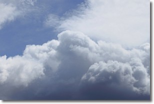
A nimbostratus cloud is similar to a stratus cloud in its formless,
smooth appearance. However, a nimbostratus cloud is darker than a stratus cloud,
because it is thicker.
Unlike a stratus cloud, a nimbostratus cloud typically brings with it the threat
of moderate to heavy precipitation. In some cases, the precipitation may evaporate
before reaching the ground, a phenomenon known as virga.
Next Topic: Precipitation
Weather Topic: What is Rain?
Home - Education - Precipitation - Rain
 Next Topic: Shelf Clouds
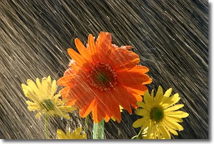
Precipitation in the form of water droplets is called rain.
Rain generally has a tendency to fall with less intensity over a greater period
of time, and when rainfall is more severe it is usually less sustained.
Rain is the most common form of precipitation and happens with greater frequency
depending on the season and regional influences. Cities have been shown to have
an observable effect on rainfall, due to an effect called the urban heat island.
Compared to upwind, monthly rainfall between twenty and forty miles downwind of
cities is 30% greater.
Next Topic: Shelf Clouds
Current conditions powered by WeatherAPI.com


