Weather Alert in Arizona
Flash Flood Warning issued August 23 at 2:50PM MST until August 23 at 4:45PM MST by NWS Flagstaff AZ
AREAS AFFECTED: Coconino, AZ
DESCRIPTION: At 250 PM MST, Doppler radar indicated thunderstorms produced heavy rain over the Pipeline Fire scar west of Highway 89. Between 0.5 and 1.5 inches of rain fell, with .60 to .85 falling within a 15 minute period. Flooding impacts will continue, but no additional rainfall is expected. Flash flooding is ongoing or expected to begin shortly. HAZARD...Life threatening flash flooding. Thunderstorms producing flash flooding in and around the Pipeline Fire scar west of Highway 89. SOURCE...Radar indicated. IMPACT...Life threatening flash flooding of areas in and around the Pipeline Fire scar west of Highway 89. Some locations that will experience flash flooding include... Schultz Pass, Pine Mountain Estates, Timberline, Hutchison Acres, Fernwood, Doney Park and Kachina Peaks Wilderness.
INSTRUCTION: Flash flooding is occurring or imminent downstream of the Pipeline Fire scar, including Timberline, Wupatki Trails, and Fernwood. People are advised to shelter in place. If outdoors, get to high ground and do not enter drainages. Do not enter flooded roads.
Want more detail? Get the Complete 7 Day and Night Detailed Forecast!
Current U.S. National Radar--Current
The Current National Weather Radar is shown below with a UTC Time (subtract 5 hours from UTC to get Eastern Time).

National Weather Forecast--Current
The Current National Weather Forecast and National Weather Map are shown below.

National Weather Forecast for Tomorrow
Tomorrow National Weather Forecast and Tomorrow National Weather Map are show below.

North America Water Vapor (Moisture)
This map shows recent moisture content over North America. Bright and colored areas show high moisture (ie, clouds); brown indicates very little moisture present; black indicates no moisture.

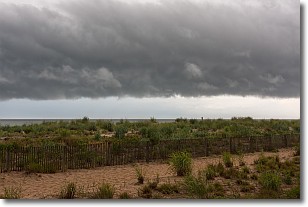
Weather Topic: What are Shelf Clouds?
Home - Education - Cloud Types - Shelf Clouds
 Next Topic: Sleet
A shelf cloud is similar to a wall cloud, but forms at the front
of a storm cloud, instead of at the rear, where wall clouds form.
A shelf cloud is caused by a series of events set into motion by the advancing
storm; first, cool air settles along the ground where precipitation has just fallen.
As the cool air is brought in, the warmer air is displaced, and rises above it,
because it is less dense. When the warmer air reaches the bottom of the storm cloud,
it begins to cool again, and the resulting condensation is a visible shelf cloud.
Next Topic: Sleet
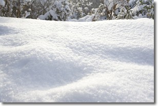
Weather Topic: What is Snow?
Home - Education - Precipitation - Snow
 Next Topic: Stratocumulus Clouds
Snow is precipitation taking the form of ice crystals. Each ice crystal, or snowflake,
has unique characteristics, but all of them grow in a hexagonal structure.
Snowfall can last for sustained periods of time and result in significant buildup
of snow on the ground.
On the earth's surface, snow starts out light and powdery, but as it begins to melt
it tends to become more granular, producing small bits of ice which have the consistency of
sand. After several cycles of melting and freezing, snow can become very dense
and ice-like, commonly known as snow pack.
Next Topic: Stratocumulus Clouds
Current conditions powered by WeatherAPI.com


