Weather Alert in Alaska
Flood Watch issued August 25 at 8:10PM AKDT until August 26 at 4:00PM AKDT by NWS Fairbanks AK
AREAS AFFECTED: Southern Seward Peninsula Coast; Interior Seward Peninsula; Eastern Norton Sound and Nulato Hills
DESCRIPTION: * WHAT...Flooding caused by excessive rainfall is possible. * WHERE...Including the following areas, Eastern Norton Sound and Nulato Hills, Interior Seward Peninsula and Southern Seward Peninsula Coast. This includes the cities of Nome, White Mountain, Golovin, Serpentine Hot Springs, Council, Haycock, Pilgrim Springs, Taylor, Unalakleet, Stebbins, St Michael, Elim, Koyuk, And Shaktoolik. * WHEN...Through Tuesday afternoon. * IMPACTS...Excessive runoff may result in flooding of rivers, creeks, streams, and other low-lying and flood-prone locations. * ADDITIONAL DETAILS... - Heavy rainfall is expected across the interior and southern Seward Peninsula as well as the eastern Norton Sound Monday afternoon through Tuesday. Rainfall amounts of 2 to 3 inches are forecast across the region, resulting in rapid rises along rivers, creeks, and streams. Smaller streams may see water rises to near or above flood stage overnight Monday night through Tuesday morning. - Http://www.weather.gov/aprfc
INSTRUCTION: You should monitor later forecasts and be alert for possible Flood Warnings. Those living in areas prone to flooding should be prepared to take action should flooding develop. Stay tuned to further developments by listening to your local radio, television, or NOAA Weather Radio for further information.
Want more detail? Get the Complete 7 Day and Night Detailed Forecast!
Current U.S. National Radar--Current
The Current National Weather Radar is shown below with a UTC Time (subtract 5 hours from UTC to get Eastern Time).

National Weather Forecast--Current
The Current National Weather Forecast and National Weather Map are shown below.

National Weather Forecast for Tomorrow
Tomorrow National Weather Forecast and Tomorrow National Weather Map are show below.

North America Water Vapor (Moisture)
This map shows recent moisture content over North America. Bright and colored areas show high moisture (ie, clouds); brown indicates very little moisture present; black indicates no moisture.

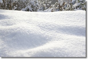
Weather Topic: What is Snow?
Home - Education - Precipitation - Snow
 Next Topic: Stratocumulus Clouds
Snow is precipitation taking the form of ice crystals. Each ice crystal, or snowflake,
has unique characteristics, but all of them grow in a hexagonal structure.
Snowfall can last for sustained periods of time and result in significant buildup
of snow on the ground.
On the earth's surface, snow starts out light and powdery, but as it begins to melt
it tends to become more granular, producing small bits of ice which have the consistency of
sand. After several cycles of melting and freezing, snow can become very dense
and ice-like, commonly known as snow pack.
Next Topic: Stratocumulus Clouds
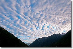
Weather Topic: What are Stratus Clouds?
Home - Education - Cloud Types - Stratus Clouds
 Next Topic: Wall Clouds
Stratus clouds are similar to altostratus clouds, but form at a
lower altitude and are identified by their fog-like appearance, lacking the
distinguishing features of most clouds.
Stratus clouds are wider than most clouds, and their base has a smooth, uniform
look which is lighter in color than a nimbostratus cloud.
The presence of a stratus cloud indicates the possibility of minor precipitation,
such as drizzle, but heavier precipitation does not typically arrive in the form
of a stratus cloud.
Next Topic: Wall Clouds
Current conditions powered by WeatherAPI.com


