Weather Alert in Georgia
Flood Warning issued August 12 at 9:32PM EDT until August 14 at 3:06PM EDT by NWS Morristown TN
AREAS AFFECTED: Catoosa, GA; Hamilton, TN
DESCRIPTION: ...The National Weather Service in Morristown TN has issued a Flood Warning for the following rivers in Tennessee...Georgia... South Chickamauga Creek Near Chickamauga TN affecting Hamilton and Catoosa Counties. For the South Chickamauga...including Chickamauga TN...Minor flooding is forecast. * WHAT...Minor flooding is forecast. * WHERE...South Chickamauga Creek near Chickamauga TN. * WHEN...From late tonight to Thursday afternoon. * IMPACTS...At 18.0 feet, Water begins to cross Mack Smith Road in Catoosa County, Georgia. Flooding begins at golf courses near the confluence of South and West Chickamauga Creeks. West Chickamauga Creek begins to overflow its banks, as well. At 19.0 feet, Water across Mack Smith Road begins to impede traffic. West Chickamauga Creek overflows its banks near the Georgia state line and inundates several roads and properties in the area. At 20.0 feet, Mack Smith Road is closed. Water crosses Lovell Field Loop, the access road around the north end of the airport runway. At 21.0 feet, Mack Smith Road and Lovell Field Loop become impassable. Water begins to come onto Airport Road, just north of the terminal complex. West Chickamauga Creek increases to near a half mile wide in places, becoming hazardous to adjacent travel in East Ridge. At 22.0 feet, Airport Road is closed to traffic. A couple of homes are slightly flooded near intersection of Mack Smith Road and May Street. Flooding becomes extensive around the north end of the airport. At 23.0 feet, Evacuations begin in some of the low lying areas around Spring Creek in the East Ridge area. * ADDITIONAL DETAILS... - At 9:15 PM EDT Tuesday the stage was 14.7 feet. - Bankfull stage is 18.0 feet. - Forecast...The river is expected to rise above flood stage late tonight to a crest of 21.5 feet tomorrow evening. It will then fall below flood stage late Thursday morning. - Flood stage is 18.0 feet. - http://www.weather.gov/safety/flood
INSTRUCTION: Turn around, don't drown when encountering flooded roads. Most flood deaths occur in vehicles. Caution is urged when walking near riverbanks. Be especially cautious at night when it is harder to recognize the dangers of flooding. Additional information is available at www.weather.gov. The next statement will be issued Wednesday morning at 1015 AM EDT.
Want more detail? Get the Complete 7 Day and Night Detailed Forecast!
Current U.S. National Radar--Current
The Current National Weather Radar is shown below with a UTC Time (subtract 5 hours from UTC to get Eastern Time).

National Weather Forecast--Current
The Current National Weather Forecast and National Weather Map are shown below.

National Weather Forecast for Tomorrow
Tomorrow National Weather Forecast and Tomorrow National Weather Map are show below.

North America Water Vapor (Moisture)
This map shows recent moisture content over North America. Bright and colored areas show high moisture (ie, clouds); brown indicates very little moisture present; black indicates no moisture.

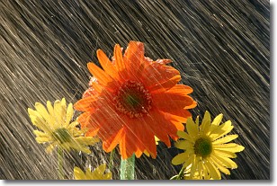
Weather Topic: What is Precipitation?
Home - Education - Precipitation - Precipitation
 Next Topic: Rain
Precipitation can refer to many different forms of water that
may fall from clouds. Precipitation occurs after a cloud has become saturated to
the point where its water particles are more dense than the air below the cloud.
In most cases, precipitation will reach the ground, but it is not uncommon for
precipitation to evaporate before it reaches the earth's surface.
When precipitation evaporates before it contacts the ground it is called Virga.
Graupel, hail, sleet, rain, drizzle, and snow are forms of precipitation, but fog
and mist are not considered precipitation because the water vapor which
constitutes them isn't dense enough to fall to the ground.
Next Topic: Rain
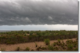
Weather Topic: What are Shelf Clouds?
Home - Education - Cloud Types - Shelf Clouds
 Next Topic: Sleet
A shelf cloud is similar to a wall cloud, but forms at the front
of a storm cloud, instead of at the rear, where wall clouds form.
A shelf cloud is caused by a series of events set into motion by the advancing
storm; first, cool air settles along the ground where precipitation has just fallen.
As the cool air is brought in, the warmer air is displaced, and rises above it,
because it is less dense. When the warmer air reaches the bottom of the storm cloud,
it begins to cool again, and the resulting condensation is a visible shelf cloud.
Next Topic: Sleet
Current conditions powered by WeatherAPI.com


