Weather Alert in Alaska
Flood Watch issued August 24 at 3:34PM AKDT until August 28 at 10:00AM AKDT by NWS Anchorage AK
AREAS AFFECTED: Kuskokwim Valley West; Kuskokwim Valley East; Interior Kuskokwim Delta; Northern Bristol Bay Coast; Inland Bristol Bay
DESCRIPTION: * WHAT...Flooding caused by excessive rainfall is possible. * WHERE...Interior Kuskokwim Delta, Kuskokwim Valley, and northern Bristol Bay. * WHEN...From Monday morning through Thursday morning. * IMPACTS...Excessive rainfall and runoff may result in flooding of small streams, and other low-lying and flood-prone locations. Significant ponding of water, areal flooding, and erosion may occur in poor drainage areas. Flooding is not expected along the main Kuskokwim River and other major rivers. * ADDITIONAL DETAILS... - An atmospheric river will bring prolonged, widespread rainfall across Southwest Alaska this week. Steadier rainfall, which can be moderate to heavy at times, is expected to begin Monday and last through at least Wednesday with showers lingering through the rest of the week. Widespread rainfall totals of 1.5 to 3 inches is expected with locally higher amounts possible. This includes the communities around the Bethel area through Crooked Creek, and the Dillingham to Aleknagik area. The highest rainfall totals of at least 2.5 to 4 inches is expected close to the mountains near Togiak and the Western Capes. - Http://www.weather.gov/safety/flood
INSTRUCTION: You should monitor later forecasts and be alert for possible Flood Warnings. Those living in areas prone to flooding should be prepared to take action should flooding develop.
Want more detail? Get the Complete 7 Day and Night Detailed Forecast!
Current U.S. National Radar--Current
The Current National Weather Radar is shown below with a UTC Time (subtract 5 hours from UTC to get Eastern Time).

National Weather Forecast--Current
The Current National Weather Forecast and National Weather Map are shown below.

National Weather Forecast for Tomorrow
Tomorrow National Weather Forecast and Tomorrow National Weather Map are show below.

North America Water Vapor (Moisture)
This map shows recent moisture content over North America. Bright and colored areas show high moisture (ie, clouds); brown indicates very little moisture present; black indicates no moisture.

Weather Topic: What is Freezing Rain?
Home - Education - Precipitation - Freezing Rain
 Next Topic: Graupel
Freezing rain is a condition where precipitation which has fallen in the form of
water droplets reaches temperatures which are below freezing and freezes upon
coming into contact
with surface objects. The result of this precipitation is a glaze of ice which
can be damaging to plants and man-made structures. A severe onset of freezing
rain which results in a very thick glaze of ice is known as an ice storm.
Next Topic: Graupel
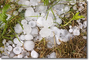
Weather Topic: What is Hail?
Home - Education - Precipitation - Hail
 Next Topic: Hole Punch Clouds
Hail is a form of precipitation which is recognized by large solid balls or
clumps of ice. Hail is created by thunderstorm clouds with strong updrafts of wind.
As the hailstones remain in the updraft, ice is deposited onto them until their
weight becomes heavy enough for them to fall to the earth's surface.
Hail storms can cause significant damage to crops, aircrafts, and man-made structures,
despite the fact that the duration is usually less than ten minutes.
Next Topic: Hole Punch Clouds
Current conditions powered by WeatherAPI.com


